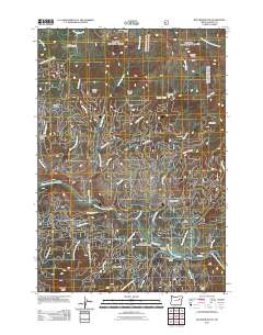
2011 Map of Boulder Butte
USGS Topo · Published 2011About this map
The Middle Fork John Day River meanders through this high-elevation landscape in the Blue Mountains, where historical mining and timber interests have left a lasting imprint. Several localized mining sites are preserved here, including the Reed Mine, Stalter Mine, and Wray Mine in the northern half, and the Stithum Mine further south. These operations, along with China Diggings, point to a history of prospecting along the numerous tributaries that feed into the river system.
Find a feature on this map
44 named features on this map. Tap any name to fly to it.
Don’t see what you’re looking for? This feature index may not catch every label — zoom into the map to look around manually.
Map Details
Editions of this 2011 Boulder Butte Map
This is the sole edition of this map. No revisions or reprints were ever made.
Other maps of this area

1949 · Susanville
USGS Topo · 1:62,500

1951 · Susanville
USGS Topo · 1:62,500

1951 · Dale
USGS Topo · 1:62,500

1951 · Bates
USGS Topo · 1:62,500

1951 · Desolation Butte
USGS Topo · 1:62,500

1955 · Canyon City
USGS Topo · 1:250,000

1959 · Canyon City
USGS Topo · 1:250,000
1987 · Bates
USGS Topo · 1:100,000
1988 · Vinegar Hill
USGS Topo · 1:24,000
1988 · Desolation Butte
USGS Topo · 1:24,000