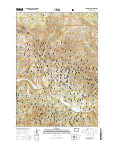
2014 Map of Boulder Butte
USGS Topo · Published 2014About this map
Squatter Flat sits near the heart of this high-elevation terrain, where the Middle Fork John Day River cuts through the canyon lands between the Umatilla National Forest and the Malhuer National Forest. This 2014 survey documents a landscape defined by its numerous meadows and springs, such as McCalpine Meadow, Bear Paw Meadow, and Crockett Spring. The drainage patterns are intricate, with Big Boulder Cr and Ruby Cr feeding the primary river system as it flows past Riverside Gulch. Several named ridges and peaks, including Boulder Butte and Myrtle Butte, provide significant landmarks within this protected forest complex. A network of primitive roads, like Up Middle Fork Rd and Co Rd 20 A, provides the only access through the steep gulches and bluffs that characterize the Grant County wilderness.
Find a feature on this map
57 named features on this map. Tap any name to fly to it.
Don’t see what you’re looking for? This feature index may not catch every label — zoom into the map to look around manually.
Map Details
Editions of this 2014 Boulder Butte Map
This is the sole edition of this map. No revisions or reprints were ever made.
Other maps of this area

1949 · Susanville
USGS Topo · 1:62,500

1951 · Susanville
USGS Topo · 1:62,500

1951 · Dale
USGS Topo · 1:62,500

1951 · Bates
USGS Topo · 1:62,500

1951 · Desolation Butte
USGS Topo · 1:62,500

1955 · Canyon City
USGS Topo · 1:250,000

1959 · Canyon City
USGS Topo · 1:250,000
1987 · Bates
USGS Topo · 1:100,000
1988 · Vinegar Hill
USGS Topo · 1:24,000
1988 · Desolation Butte
USGS Topo · 1:24,000