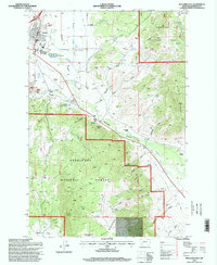
1996 Map of Boulder East
USGS Topo · Published 1998About this map
Boulder serves as the focal point for this mid-1990s survey, where the Boulder River School & Hospital and a local Cemetery sit just north of the Boulder River. The landscape transitions from the developed Boulder Valley into the high country of the Deerlodge National Forest. Significant historical mining activity is evidenced by the Chinese Diggings Placer Mine and other Placer Mine sites along the river's path, while agricultural operations like Larson Ranch and McCauley Ranch are established along the foothills. The terrain is deeply incised by numerous drainages such as McCarty Gulch and Killian Gulch, rising toward the heights of Bull Mountain and Ryan Mountain. This record captures a mix of institutional grounds, aviation at Boulder Airfield, and the water management systems of the Ditch and Sewage Disposal Ponds that supported the community's infrastructure.
Find a feature on this map
63 named features on this map. Tap any name to fly to it.
Don’t see what you’re looking for? This feature index may not catch every label — zoom into the map to look around manually.
Map Details
Editions of this 1996 Boulder East Map
This is the sole edition of this map. No revisions or reprints were ever made.
Other maps of this area

1886 · Fort Logan
USGS Topo · 1:250,000

1889 · Helena
USGS Topo · 1:250,000

1893 · Helena
USGS Topo · 1:250,000

1899 · Boulder
USGS Topo · 1:125,000

1899 · Helena
USGS Topo · 1:250,000

1903 · Helena
USGS Topo · 1:250,000

1947 · Butte
USGS Topo · 1:250,000

1948 · White Sulphur Springs
USGS Topo · 1:250,000

1950 · Devils Fence
USGS Topo · 1:62,500

1950 · Jefferson City
USGS Topo · 1:62,500