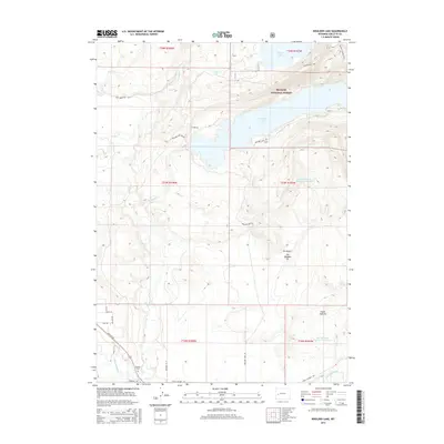
2015 Map of Boulder Lake
USGS Topo · Published 2015About this map
The Bridger National Forest dominates the northern expanse of this landscape, where the foothills of the Wind River Range meet the high plains. Central to the geography is Boulder Lake, fed by Falls Cr and Pole Cr as they descend from the higher elevations. The water management system is documented through the presence of the Boulder Lake Dam Rd and designated areas like Boulder Lake Reservoir Number 7. To the south, the terrain transitions toward the valley of the New Fork River, near where State Highway 353 and Paradise Rd provide access to the rural outskirts of the Boulder community. Local resource extraction is evident at the Elk Meadow Pit and Indian Trail Pit, while the Boulder Cem serves as a significant landmark for those tracing regional family history and early settlement patterns in Sublette County.
Find a feature on this map
37 named features on this map. Tap any name to fly to it.
Don’t see what you’re looking for? This feature index may not catch every label — zoom into the map to look around manually.
Map Details
Editions of this 2015 Boulder Lake Map
This is the sole edition of this map. No revisions or reprints were ever made.
Other maps of this area

1955 · Lander
USGS Topo · 1:250,000

1958 · Lander
USGS Topo · 1:250,000

1961 · Lander
USGS Topo · 1:250,000

1964 · Fremont Butte
USGS Topo · 1:24,000

1964 · Two Buttes Reservoir
USGS Topo · 1:24,000

1964 · Boulder Lake
USGS Topo · 1:24,000

1964 · Boulder
USGS Topo · 1:24,000
1964 · Pinedale
USGS Topo · 1:24,000

1964 · Fremont Lake South
USGS Topo · 1:24,000
1968 · Fayette Lake
USGS Topo · 1:24,000