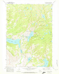
1968 Map of Fayette Lake
USGS Topo · Published 1972About this map
The glacial waters of Fayette Lake, Half Moon Lake, and Burnt Lake dominate this high-altitude landscape within the Bridger National Forest. The 1968 survey reveals a terrain defined by water and wood, where the Wilderness Boundary separates the more accessible recreation areas from the protected Bridger Wilderness. A network of historic paths, including the Pole Creek Trail and Sweeney Creek Trail, facilitates travel through the drainage basins of Pole Creek and Sweeney Creek. Human presence is marked by isolated landmarks such as Blacks Cabin and the Upper Half Moon Campground, while a Gaging Sta on the southern reach of Little Half Moon Lake indicates the importance of hydrological monitoring in this watershed. The map illustrates the complex topography of Half Moon Mountain and Fortification Mountain, providing a clear view of the area's natural boundaries before later developments.
Find a feature on this map
36 named features on this map. Tap any name to fly to it.
Don’t see what you’re looking for? This feature index may not catch every label — zoom into the map to look around manually.
Map Details
Editions of this 1968 Fayette Lake Map
3 editions found
Other maps of this area

1909 · Fremont Peak
USGS Topo · 1:125,000

1955 · Thermopolis
USGS Topo · 1:250,000

1955 · Lander
USGS Topo · 1:250,000

1958 · Lander
USGS Topo · 1:250,000

1958 · Thermopolis
USGS Topo · 1:250,000

1961 · Lander
USGS Topo · 1:250,000

1962 · Thermopolis
USGS Topo · 1:250,000

1964 · Boulder Lake
USGS Topo · 1:24,000
1964 · Pinedale
USGS Topo · 1:24,000

1964 · Fremont Lake South
USGS Topo · 1:24,000