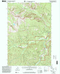
1998 Map of Boulder Peak
USGS Topo · Published 2002About this map
The Selway - Bitterroot Wilderness dominates the northern half of this late-twentieth-century landscape, where the rugged peaks of the Bitterroot Range reach their heights at Boulder Peak. To the south, the Bitterroot National Forest gives way to concentrated human activity along the West Fork Bitterroot River corridor. This valley floor serves as a hub for both public management and recreation, anchored by the West Fork Ranger Station and several established sites such as the Sam Billings Memorial Campground and Rombo Creek Campground.
Find a feature on this map
51 named features on this map. Tap any name to fly to it.
Don’t see what you’re looking for? This feature index may not catch every label — zoom into the map to look around manually.
Map Details
Editions of this 1998 Boulder Peak Map
This is the sole edition of this map. No revisions or reprints were ever made.
Other maps of this area

1956 · Elk City
USGS Topo · 1:250,000

1960 · Elk City
USGS Topo · 1:250,000

1960 · Painted Rocks Lake
USGS Topo · 1:62,500

1960 · Piquett Mountain
USGS Topo · 1:62,500

1964 · Burnt Ridge
USGS Topo · 1:24,000

1964 · Boulder Peak
USGS Topo · 1:24,000
1964 · Trapper Peak
USGS Topo · 1:24,000
1964 · Mount Jerusalem
USGS Topo · 1:24,000
1964 · Tin Cup Lake
USGS Topo · 1:24,000

1964 · Piquett Creek
USGS Topo · 1:24,000