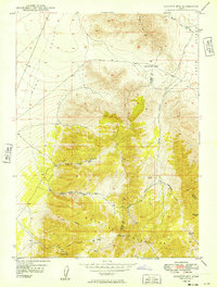
1949 Map of Boulter Mts
USGS Topo · Published 1949About this map
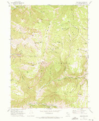
Scranton sits at the head of Scranton Canyon, serving as a focal point for the mining activity that once defined this section of the Boulter Mountains. By the late 1940s, when these aerial photographs were field-checked, the many mining operations throughout the range were noted as abandoned. The landscape is a complex of high ridges and deep drainages, including Mill Canyon, Miners Canyon, and Barlow Canyon, which descend toward the floor of Rush Valley. This 1949 edition captures a transition in land use, showing the precise locations of the Scranton Mine, Hot Stuff Mine, and New Bullion Mine before their physical remains faded. The intersection of Tooele, Utah, and Juab counties occurs within these peaks, near landmarks like Bismark Hill and the seasonal basin of Dry Lake.
Find a feature on this map
21 named features on this map. Tap any name to fly to it.
Don’t see what you’re looking for? This feature index may not catch every label — zoom into the map to look around manually.
Map Details
Editions of this 1949 Boulter Mts Map
This is the sole edition of this map. No revisions or reprints were ever made.
Other maps of this area

1912 · Randolph
USGS Topo · 1:125,000

1914 · Logan
USGS Topo · 1:125,000

1916 · Logan
USGS Topo · 1:125,000

1954 · Ogden
USGS Topo · 1:250,000

1958 · Ogden
USGS Topo · 1:250,000

1960 · Ogden
USGS Topo · 1:250,000
1969 · Boulder Mtn
USGS Topo · 1:24,000
1969 · Porcupine Reservoir
USGS Topo · 1:24,000
1969 · Hardware Ranch
USGS Topo · 1:24,000
1969 · Logan Peak
USGS Topo · 1:24,000