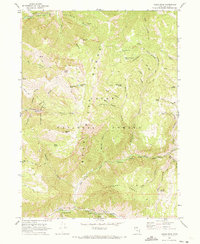
1969 Map of Logan Peak
USGS Topo · Published 1973About this map
The Bear River Range dominates this late-1960s study of the Utah high country, centered on the prominent Logan Peak. The landscape is a network of named drainages like Mill Hollow and Welches Hollow, supporting a seasonal economy of recreation and resource management. Evidence of local industry and infrastructure appears in the Quarry near Rocky Canyon and the Aqueduct system near the Logan River. The map reveals a high-altitude wilderness used for livestock and forest service operations, marked by Adams Corral and the Blacksmith Fork Guard Station. Travelers moved through the terrain via an extensive system of established routes, including the Richards Pack Trail and several Jeep Trails, connecting various campsites such as Bridger Campground and White Bedground Camp. This detailed topographic record captures the transition from working forest to recreational destination in the Cache National Forest.
Find a feature on this map
60 named features on this map. Tap any name to fly to it.
Don’t see what you’re looking for? This feature index may not catch every label — zoom into the map to look around manually.
Map Details
Editions of this 1969 Logan Peak Map
This is the sole edition of this map. No revisions or reprints were ever made.
Other maps of this area

1914 · Logan
USGS Topo · 1:125,000

1916 · Logan
USGS Topo · 1:125,000

1949 · Boulter Mts
USGS Topo · 1:24,000

1954 · Ogden
USGS Topo · 1:250,000

1955 · Paradise
USGS Topo · 1:24,000

1958 · Ogden
USGS Topo · 1:250,000

1960 · Ogden
USGS Topo · 1:250,000

1961 · Logan
USGS Topo · 1:24,000
1964 · Smithfield
USGS Topo · 1:24,000

1969 · Boulder Mtn
USGS Topo · 1:24,000