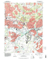
1995 Map of Bound Brook
USGS Topo · Published 1998About this map
The Raritan River and the historic Delaware and Raritan Canal form the central axis of this landscape, tracing the industrial and transportation corridor between Somerville, Bound Brook, and Manville. The map reflects a densely settled region where mid-century infrastructure and older religious or educational institutions coexist. Notable landmarks include the Alma White College at Zarephath and the Ukrainian Village to the southeast, illustrating the diverse cultural and institutional development of the area.
Find a feature on this map
83 named features on this map. Tap any name to fly to it.
Don’t see what you’re looking for? This feature index may not catch every label — zoom into the map to look around manually.
Map Details
Editions of this 1995 Bound Brook Map
This is the sole edition of this map. No revisions or reprints were ever made.
Other maps of this area

1888 · Plainfield
USGS Topo · 1:62,500

1888 · New Brunswick
USGS Topo · 1:62,500

1888 · Princeton
USGS Topo · 1:62,500

1891 · Somerville
USGS Topo · 1:62,500

1893 · New Brunswick
USGS Topo · 1:62,500

1893 · Plainfield
USGS Topo · 1:62,500

1893 · Somerville
USGS Topo · 1:62,500

1894 · Princeton
USGS Topo · 1:62,500

1898 · Plainfield
USGS Topo · 1:62,500

1898 · Somerville
USGS Topo · 1:62,500
Featured Places
- Franklin Township, NJ
- Piscataway Township, NJ
- Bridgewater Township, NJ
- Hillsborough Township, NJ
- Middlesex, NJ