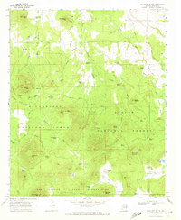
1968 Map of Boundary Butte
USGS Topo · Published 1973About this map
Sitgreaves National Forest and Apache National Forest converge in this high-altitude landscape of eastern Arizona, where the timbered uplands meet the northern boundary of the Fort Apache Indian Reservation. The 1968 survey reveals a terrain defined by volcanic features and water management, with numerous cattle tanks like Arab Tank and Porcupine Tank scattered among family-named landmarks. The presence of the Vernon Cem and scattered ranching outposts like Carlock Ranch and Neagle Ranch illustrates the area's rural livestock heritage.
Find a feature on this map
61 named features on this map. Tap any name to fly to it.
Don’t see what you’re looking for? This feature index may not catch every label — zoom into the map to look around manually.
Map Details
Editions of this 1968 Boundary Butte Map
3 editions found
Other maps of this area

1886 · St Johns
USGS Topo · 1:250,000

1892 · St Johns
USGS Topo · 1:250,000

1954 · Saint Johns
USGS Topo · 1:250,000

1957 · Saint Johns
USGS Topo · 1:250,000

1958 · Saint Johns
USGS Topo · 1:250,000

1961 · McNary
USGS Topo · 1:62,500

1962 · Saint Johns
USGS Topo · 1:250,000

1968 · Boundary Butte
USGS Topo · 1:24,000

1969 · Whiting Knoll
USGS Topo · 1:24,000
1969 · Horseshoe Cienega
USGS Topo · 1:24,000