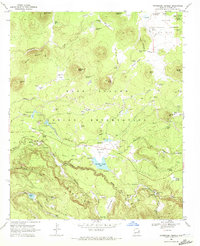
1969 Map of Horseshoe Cienega
USGS Topo · Published 1972About this map
Mogollon Rim dominates the southern landscape of this 1969 survey, where the Fort Apache Indian Reservation meets the Apache National Forest. This high-altitude terrain is defined by a series of mountain springs and "cienegas," or marshy wetlands, such as Horseshoe Cienega and Yellow Jacket Cienega. The map reveals a land utilized for both recreation and industry, featuring numerous campgrounds alongside evidence of former logging operations, most notably the Old Railroad Grade winding through the hills. Remote outposts and dwellings like Ryan Ranch, Thode Cabin, and the C C Fireman Cabin suggest a history of forest management and ranching. Significant water features including Horseshoe Cienega Lake and the North Fork White River provide the primary drainage for this timbered territory.
Find a feature on this map
78 named features on this map. Tap any name to fly to it.
Don’t see what you’re looking for? This feature index may not catch every label — zoom into the map to look around manually.
Map Details
Editions of this 1969 Horseshoe Cienega Map
This is the sole edition of this map. No revisions or reprints were ever made.
Other maps of this area

1886 · St Johns
USGS Topo · 1:250,000

1892 · St Johns
USGS Topo · 1:250,000

1954 · Clifton
USGS Topo · 1:250,000

1954 · Saint Johns
USGS Topo · 1:250,000

1957 · Clifton
USGS Topo · 1:250,000

1957 · Saint Johns
USGS Topo · 1:250,000

1958 · Clifton
USGS Topo · 1:250,000

1958 · Saint Johns
USGS Topo · 1:250,000

1961 · McNary
USGS Topo · 1:62,500

1962 · Clifton
USGS Topo · 1:250,000