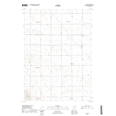
2017 Map of Bovee
USGS Topo · Published 2017About this map
The small settlement of Bovee serves as the focal point for this agrarian landscape in South Dakota. Defined by a strictly organized grid of sectional roads like Bovee Rd and 280th St, the area is punctuated by the remnants of earlier pioneer communities. Family history is well-represented through numerous burial grounds, including Edgerton Cem, Bloomington Cem, Platte Valley Cem, and Jasper Cem, which are scattered throughout the townships. The drainage of the land is defined by several seasonal watercourses such as Edgerton Cr and Campbell Cr, which cut through the plains. A notable local landmark, Took Tay Hill, rises above the surrounding fields, providing a rare point of elevation in a region primarily dedicated to large-scale agriculture and rural homesteads.
Find a feature on this map
32 named features on this map. Tap any name to fly to it.
Don’t see what you’re looking for? This feature index may not catch every label — zoom into the map to look around manually.
Map Details
Editions of this 2017 Bovee Map
This is the sole edition of this map. No revisions or reprints were ever made.
Other maps of this area

1955 · Mitchell
USGS Topo · 1:250,000

1959 · Mitchell
USGS Topo · 1:250,000

1964 · Campbell Creek
USGS Topo · 1:24,000

1964 · Whetstone Bay
USGS Topo · 1:24,000

1964 · Lake Andes NW
USGS Topo · 1:24,000

1977 · Lake Andes NW
USGS Topo · 1:24,000

1979 · Castalia
USGS Topo · 1:24,000
1979 · Bovee
USGS Topo · 1:24,000
1979 · Geddes
USGS Topo · 1:24,000

1979 · Joubert
USGS Topo · 1:24,000