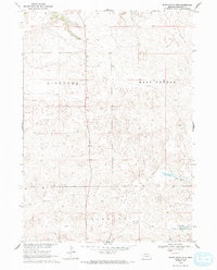
1969 Map of Bovee Valley West
USGS Topo · Published 1993About this map
The high plains of Sheridan County are defined by the transition between the distinct topographic zones of Niobrara, East Gordon, and Kinkaid. In the southeast corner of this late 1960s survey, the namesake Bovee Valley serves as a focal point for local history and genealogy, anchored by the presence of the Hinchley Sch. The landscape is characterized by its reliance on scarce water sources, with the Snake River winding through the southeastern terrain while a natural Spring and various wells provide essential relief for the cattle ranching operations common to this part of the Nebraska Sandhills. This map represents the area as it was recorded for the Department of the Interior's Missouri River Basin development program, showing the distribution of rural homesteads and cattle-associated infrastructure that has long sustained the regional economy.
Find a feature on this map
9 named features on this map. Tap any name to fly to it.
Don’t see what you’re looking for? This feature index may not catch every label — zoom into the map to look around manually.
Map Details
Editions of this 1969 Bovee Valley West Map
2 editions found
Other maps of this area

1948 · Twin Lakes
USGS Topo · 1:62,500

1948 · Spade Ranch
USGS Topo · 1:62,500

1950 · Twin Lakes
USGS Topo · 1:62,500

1950 · Spade Ranch
USGS Topo · 1:62,500

1955 · Alliance
USGS Topo · 1:250,000

1957 · Alliance
USGS Topo · 1:250,000

1958 · Alliance
USGS Topo · 1:250,000

1969 · Rushville 4 SW
USGS Topo · 1:24,000

1969 · Rushville SE
USGS Topo · 1:24,000
1969 · Rushville 4 NE
USGS Topo · 1:24,000