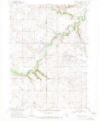
1969 Map of Rushville 4 NE
USGS Topo · Published 1972About this map
The Niobrara River carves a deep valley through the northern High Plains of Nebraska, serving as the central geographic feature of this late 1960s survey. The landscape is defined by its water-crossings and early rural infrastructure, specifically the Lavaca Bridge, Case Bridge, and Hardin Bridge which provided vital connections across the winding river. Along the northern plateaus, the presence of the Longview Sch and Lavaca Cem indicates the centers of a dispersed ranching community.
Find a feature on this map
13 named features on this map. Tap any name to fly to it.
Don’t see what you’re looking for? This feature index may not catch every label — zoom into the map to look around manually.
Map Details
Editions of this 1969 Rushville 4 NE Map
2 editions found
Other maps of this area

1950 · Irwin
USGS Topo · 1:62,500

1951 · Irwin
USGS Topo · 1:62,500

1951 · Gypsy Valley
USGS Topo · 1:62,500

1955 · Alliance
USGS Topo · 1:250,000

1957 · Alliance
USGS Topo · 1:250,000

1957 · Valentine
USGS Topo · 1:250,000

1958 · Alliance
USGS Topo · 1:250,000

1959 · Valentine
USGS Topo · 1:250,000

1969 · Rushville 4 SW
USGS Topo · 1:24,000

1969 · Gordon
USGS Topo · 1:24,000