
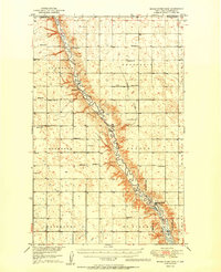
1949 Map of Bowbells NE
USGS Topo · Published 1949About this map
The international border between Canada and the United States defines the northern edge of this North Dakota landscape, where the Saskatchewan and North Dakota boundary meets the rural prairie. This mid-century survey centers on the significant waterway of Des Lacs and Upper Des Lacs Lake, much of which is contained within the Upper Des Lacs Migratory Bird Refuge. The map reveals a highly structured rural educational system, with several numbered schoolhouses dotting the sections, including Lakeside Sch No 2 and North Star Sch No 4. The terrain is marked by the Tenth Guide Meridian and the border between Burke and Renville counties. Engineering of the water system is evidenced by the Spillway Elev 1786, while regional names like Rockford and Lakeview identify the township divisions of this agricultural frontier.
Find a feature on this map
19 named features on this map. Tap any name to fly to it.
Don’t see what you’re looking for? This feature index may not catch every label — zoom into the map to look around manually.
Map Details
Editions of this 1949 Bowbells NE Map
This is the sole edition of this map. No revisions or reprints were ever made.
Other maps of this area

1947 · Bowbells NW
USGS Topo · 1:24,000

1947 · Bowbells
USGS Topo · 1:24,000

1948 · Mouse River Park NW
USGS Topo · 1:24,000

1949 · Bowbells
USGS Topo · 1:24,000

1949 · Mouse River Park NW
USGS Topo · 1:24,000

1949 · Bowbells SE
USGS Topo · 1:24,000

1949 · Bowbells NW
USGS Topo · 1:24,000

1949 · Mouse River Park SW
USGS Topo · 1:24,000

1950 · Bowbells
USGS Topo · 1:62,500
1950 · Mouse River Park
USGS Topo · 1:62,500