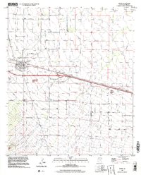
1996 Map of Bowie
USGS Topo · Published 2002About this map
Bowie serves as a critical junction in this arid basin, centered on the Southern Pacific rail line and Interstate 10. The town’s social and civic infrastructure is visible through the local High Sch and the Desert Rest (Cem) located just northwest of the main settlement. The landscape is defined by its industrial and utility footprint, including a Substation, a Pipeline, and a Landing Strip, alongside numerous scattered groundwater extraction points such as Well 3716 and Well 3680.
Find a feature on this map
44 named features on this map. Tap any name to fly to it.
Don’t see what you’re looking for? This feature index may not catch every label — zoom into the map to look around manually.
Map Details
Editions of this 1996 Bowie Map
This is the sole edition of this map. No revisions or reprints were ever made.
Other maps of this area

1917 · San Simon
USGS Topo · 1:125,000

1922 · Willcox
USGS Topo · 1:125,000

1926 · Cochise Head
USGS Topo · 1:62,500

1928 · Bowie
USGS Topo · 1:62,500

1943 · Dos Cabezas
USGS Topo · 1:62,500

1944 · Fisher Hills
USGS Topo · 1:62,500

1949 · Bowie
USGS Topo · 1:62,500

1950 · Bowie
USGS Topo · 1:62,500

1950 · Cochise Head
USGS Topo · 1:62,500

1954 · Silver City
USGS Topo · 1:250,000