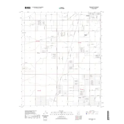
2020 Map of Bowlin Ranch
USGS Topo · Published 2020About this map
Deming anchors the northern reaches of this landscape, where the street grid transitions into the expansive agricultural and ranching tracts of southern New Mexico. The map illustrates a distinctive pattern of rural development, with named lanes such as Sarape, Alhambra, and Lagremas Rd Sw suggesting local cultural influences on the land's organization. To the south, the settlement of Sunshine sits amidst a network of irrigation and local access roads, while the Snake Hills provide a rare topographic interruption to the otherwise level terrain. Historically significant routes like Columbus Rd and Dona Ana Rd Sw facilitate movement through this high-desert region. The presence of Bowlin Ranch and Pulpotio Bareas highlights the area's ongoing identity as a site of desert habitation and livestock management, with the Jones Spring Draw marking the natural drainage path through the quadrangle.
Find a feature on this map
158 named features on this map. Tap any name to fly to it.
Don’t see what you’re looking for? This feature index may not catch every label — zoom into the map to look around manually.
Map Details
Editions of this 2020 Bowlin Ranch Map
This is the sole edition of this map. No revisions or reprints were ever made.
Other maps of this area

1899 · Deming
USGS Topo · 1:125,000

1915 · Deming
USGS Topo · 1:125,000

1955 · Las Cruces
USGS Topo · 1:250,000

1958 · Las Cruces
USGS Topo · 1:250,000

1964 · Deming West
USGS Topo · 1:24,000
1964 · Williams Ranch
USGS Topo · 1:24,000

1965 · South Peak
USGS Topo · 1:24,000

1965 · Deming East
USGS Topo · 1:24,000
1965 · Midway Butte
USGS Topo · 1:24,000
1965 · Red Mountain
USGS Topo · 1:24,000