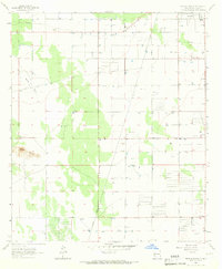
1965 Map of Bowlin Ranch
USGS Topo · Published 1967About this map
Bowlin Ranch and the isolated Sunshine Sch anchor this mid-1960s landscape in Luna County, where the desert terrain is defined by low-relief features and essential water management. The Snake Hills provide a distinct geological break in the southwest, while the remainder of the quadrangle is etched with the Hermanas Grade and a network of unimproved roads and fence lines that suggest a rural ranching economy. Resource extraction is evident through scattered Gravel Pits and a Sandpit, alongside a major linear Pipeline cutting across the northern half of the survey. Numerous Wells and the Jones Spring Draw highlight the critical role of water infrastructure in sustaining this arid New Mexico environment during the mid-twentieth century.
Find a feature on this map
10 named features on this map. Tap any name to fly to it.
Don’t see what you’re looking for? This feature index may not catch every label — zoom into the map to look around manually.
Map Details
Editions of this 1965 Bowlin Ranch Map
This is the sole edition of this map. No revisions or reprints were ever made.
Other maps of this area

1899 · Deming
USGS Topo · 1:125,000

1915 · Deming
USGS Topo · 1:125,000

1955 · Las Cruces
USGS Topo · 1:250,000

1958 · Las Cruces
USGS Topo · 1:250,000

1964 · Deming West
USGS Topo · 1:24,000
1964 · Williams Ranch
USGS Topo · 1:24,000

1965 · South Peak
USGS Topo · 1:24,000

1965 · Deming East
USGS Topo · 1:24,000
1965 · Midway Butte
USGS Topo · 1:24,000
1965 · Red Mountain
USGS Topo · 1:24,000