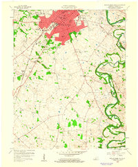
1959 Map of Bowling Green South
USGS Topo · Published 1960About this map
Bowling Green serves as the focal point of this 1959 survey, showing the city's southward expansion toward Memphis Junction and the winding course of the Barren River. The landscape is a mix of civic institutions and educational centers, including the campus of Western State College and the Western Trade Sch, alongside the industrial presence of several Oil Wells to the northwest. The Louisville and Nashville railroad corridor anchors the transportation network, running parallel to the Dixie Highway and Nashville Road.
Find a feature on this map
53 named features on this map. Tap any name to fly to it.
Don’t see what you’re looking for? This feature index may not catch every label — zoom into the map to look around manually.
Map Details
Editions of this 1959 Bowling Green South Map
This is the sole edition of this map. No revisions or reprints were ever made.
Other maps of this area

1914 · Little Muddy
USGS Topo · 1:62,500

1921 · Bowling Green
USGS Topo · 1:62,500

1922 · Brownsville
USGS Topo · 1:62,500

1923 · Bowling Green
USGS Topo · 1:62,500

1923 · Brownsville
USGS Topo · 1:62,500

1951 · Woodburn
USGS Topo · 1:24,000

1952 · Rockfield
USGS Topo · 1:24,000

1954 · Evansville
USGS Topo · 1:250,000

1954 · Bowling Green North
USGS Topo · 1:24,000

1954 · Drake
USGS Topo · 1:24,000
Featured Places
- Bowling Green, KY
- Briarwood Manor, Bowling Green
- Three Springs, KY
- Eastland Park, Bowling Green
- Greenwood, Bowling Green