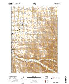
2020 Map of Bowlus Hill
USGS Topo · Published 2020About this map
Milton-Freewater borders the western edge of this landscape, where the agricultural flats of the Walla-Walla Valley meet the rising foothills of the Blue Mountains. The drainage system is central to the area's geography, defined by the winding Walla Walla River and its tributaries like Couse Cr and Birch Cr. Man-made infrastructure reveals the historical management of this watershed, from irrigation via the Dorothy Ditch to crossings at Joe West Bridge and Dorothy Bridge. Higher elevations to the east are marked by prominent features such as Bowlus Hill, Blalock Mtn, and Lincton Mtn, while the interior is punctuated by deep drainages like Bowlus Canyon and Cup Gulch. Local history is anchored by the Bowlus Cem, situated near several family-named roads that suggest the generational ranching and farming heritage of Umatilla County.
Find a feature on this map
47 named features on this map. Tap any name to fly to it.
Don’t see what you’re looking for? This feature index may not catch every label — zoom into the map to look around manually.
Map Details
Editions of this 2020 Bowlus Hill Map
This is the sole edition of this map. No revisions or reprints were ever made.
Other maps of this area

1919 · Walla Walla
USGS Topo · 1:125,000

1921 · Walla Walla
USGS Topo · 1:125,000

1953 · Pendleton
USGS Topo · 1:250,000

1953 · Walla Walla
USGS Topo · 1:250,000

1956 · Pendleton
USGS Topo · 1:250,000

1958 · Walla Walla
USGS Topo · 1:250,000

1963 · Blalock Mountain
USGS Topo · 1:24,000

1963 · Peterson Ridge
USGS Topo · 1:24,000

1964 · Milton-Freewater
USGS Topo · 1:24,000

1964 · Athena
USGS Topo · 1:24,000