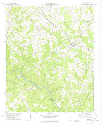
1972 Map of Bowman
USGS Topo · Published 1974About this map
The Broad River winds through the southern portion of this landscape, serving as the physical boundary between Elbert and Madison counties. In the early 1970s, the area's rural character was defined by a network of country churches and small settlements connected by the Southern railroad line. The town of Bowman serves as the primary hub, with industrial infrastructure like a Pumping Sta and Sewage Disposal Ponds reflecting the localized development of the era. Further west, the settlement of Vanna is marked by Vanna Chapel and proximity to the indefinite boundary of Hart County. Numerous small watercourses, including Mill Shoal Creek and Butler Creek, carve through the terrain, each dotted with community landmarks like Mill Shoal Ch and Pleasant Grove Ch that anchor the local genealogy of this Georgia Piedmont region.
Find a feature on this map
32 named features on this map. Tap any name to fly to it.
Don’t see what you’re looking for? This feature index may not catch every label — zoom into the map to look around manually.
Map Details
Editions of this 1972 Bowman Map
This is the sole edition of this map. No revisions or reprints were ever made.
Other maps of this area

1891 · Carnesville
USGS Topo · 1:125,000

1893 · Elberton
USGS Topo · 1:125,000

1954 · Greenville
USGS Topo · 1:250,000

1958 · Greenville
USGS Topo · 1:250,000

1958 · Danielsville
USGS Topo · 1:62,500

1958 · Elberton
USGS Topo · 1:62,500

1959 · Carnesville
USGS Topo · 1:24,000

1959 · Royston
USGS Topo · 1:24,000

1959 · Hartwell
USGS Topo · 1:24,000
1972 · Danielsville South
USGS Topo · 1:24,000