
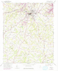
1959 Map of Hartwell
USGS Topo · Published 1961About this map
Hartwell serves as the focal point of this 1959 survey, situated at the terminus of the Hartwell Railway just as the regional landscape was being reshaped by the rising waters of the Hartwell Reservoir. The map documents a community deeply rooted in its local institutions, evidenced by the high density of rural churches such as Bio Ch, Bethesda Ch, and Shiloh Ch that dot the landscape south of the city.
Find a feature on this map
43 named features on this map. Tap any name to fly to it.
Don’t see what you’re looking for? This feature index may not catch every label — zoom into the map to look around manually.
Map Details
Editions of this 1959 Hartwell Map
2 editions found
Other maps of this area

1891 · Carnesville
USGS Topo · 1:125,000

1893 · Elberton
USGS Topo · 1:125,000

1954 · Greenville
USGS Topo · 1:250,000

1958 · Greenville
USGS Topo · 1:250,000

1958 · Danielsville
USGS Topo · 1:62,500

1958 · Elberton
USGS Topo · 1:62,500

1959 · Hartwell Dam
USGS Topo · 1:24,000

1959 · Lavonia
USGS Topo · 1:24,000

1959 · Hartwell NE
USGS Topo · 1:24,000

1959 · Royston
USGS Topo · 1:24,000