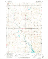
1973 Map of Bowman SE
USGS Topo · Published 1977About this map
Spring Creek meanders southward through the prairie of southwest North Dakota, eventually feeding the northern reaches of Bowman-Haley Lake. The landscape is organized into rural townships including Talbot, Boyesen, and Minnehaha, where the early 1970s terrain is marked by isolated landmarks and small-scale operations. Evidence of rural education and transport are preserved through the location of the Eden School and the path of the Stage Road, which cuts across the central section of the quadrangle. The survey captures the transition of the local hydrology, from the small Gaging Sta to the confluence of Cold Turkey Creek and Alkali Cr. Local landmarks like Watson and the presence of scattered wells reflect the ranching and resource extraction character of this region during the era.
Find a feature on this map
15 named features on this map. Tap any name to fly to it.
Don’t see what you’re looking for? This feature index may not catch every label — zoom into the map to look around manually.
Map Details
Editions of this 1973 Bowman SE Map
This is the sole edition of this map. No revisions or reprints were ever made.
Other maps of this area

1935 · Reva
USGS Topo · 1:125,000

1953 · Dickinson
USGS Topo · 1:250,000

1954 · Lemmon
USGS Topo · 1:250,000

1957 · Dickinson
USGS Topo · 1:250,000

1957 · Lemmon
USGS Topo · 1:250,000

1968 · Bowman SW
USGS Topo · 1:24,000

1968 · Bowman
USGS Topo · 1:24,000

1968 · Eagles Nest Butte
USGS Topo · 1:24,000

1968 · Bowman-Haley Dam
USGS Topo · 1:24,000

1968 · Tepee Buttes
USGS Topo · 1:24,000