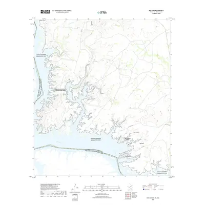
2019 Map of Box Canyon
USGS Topo · Published 2019About this map
Amistad National Recreation Area dominates this section of the Texas-Mexico border, where the convoluted shoreline of the reservoir meets the arid landscape of Val Verde County. The international boundary between the United States of America and Estados Unidos Mexicanos follows the original course of the Rio Grande, now submerged beneath the deep waters of the lake. Small residential developments including Amistad Acres, Box Canyon Estates, and Amistad are clustered near the water's edge, serviced by local routes like Box Canyon Dr and Amistad Ave. To the north, the terrain is defined by rugged drainage systems such as Chapote Draw, Cow Cr, and Live Oak Cr, which feed into the primary reservoir. The location of Goodenough Springs within the inundated canyon highlights how the damming of the river transformed the regional hydrology, turning a desert river valley into a complex aquatic environment.
Find a feature on this map
19 named features on this map. Tap any name to fly to it.
Don’t see what you’re looking for? This feature index may not catch every label — zoom into the map to look around manually.
Map Details
Editions of this 2019 Box Canyon Map
This is the sole edition of this map. No revisions or reprints were ever made.
Other maps of this area

1941 · Feely
USGS Topo · 1:62,500

1943 · Devils River
USGS Topo · 1:62,500

1944 · Devils River
USGS Topo · 1:62,500

1944 · Mouth Of Pecos
USGS Topo · 1:62,500

1958 · Del Rio
USGS Topo · 1:250,000

1964 · Del Rio
USGS Topo · 1:250,000

1972 · Amistad Dam
USGS Topo · 1:24,000

1972 · California Creek
USGS Topo · 1:24,000

1972 · Seminole Canyon
USGS Topo · 1:24,000
1972 · Zuberbueler Bend
USGS Topo · 1:24,000