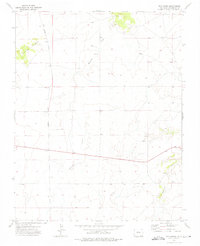
1972 Map of Box Ranch
USGS Topo · Published 1976About this map
Box Ranch sits at the northern edge of this high-plains landscape in southeastern Colorado, where the winding drainage of Bachicha Creek carves through the terrain. The map captures a transition in topography defined by Piñon Ridge to the northwest and the deep incisions of Chacuaco Creek to the southeast. These ephemeral watercourses and scattered springs suggest a land primarily utilized for large-scale ranching and grazing during the early 1970s. A prominent Pipeline cuts a straight path across the western sections, crossing township boundaries between Range 58 West and Range 57 West. This utility infrastructure, alongside a network of unimproved roads and fence lines, reflects the sparse but functional industrial and agricultural footprint in this corner of Las Animas County.
Find a feature on this map
8 named features on this map. Tap any name to fly to it.
Don’t see what you’re looking for? This feature index may not catch every label — zoom into the map to look around manually.
Map Details
Editions of this 1972 Box Ranch Map
This is the sole edition of this map. No revisions or reprints were ever made.
Other maps of this area

1891 · Mesa De Maya
USGS Topo · 1:125,000

1893 · Mesa de Maya
USGS Topo · 1:125,000

1955 · La Junta
USGS Topo · 1:250,000

1958 · La Junta
USGS Topo · 1:250,000

1968 · La Junta
USGS Topo · 1:250,000
1972 · Branson SE
USGS Topo · 1:24,000

1972 · Miners Peak
USGS Topo · 1:24,000

1972 · Doss Canyon South
USGS Topo · 1:24,000
1972 · Branson
USGS Topo · 1:24,000
1972 · Painted Canyon
USGS Topo · 1:24,000