
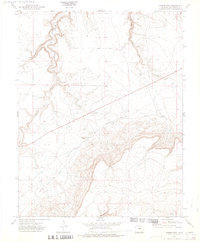
1972 Map of Miners Peak
USGS Topo · Published 1975About this map
Miners Peak and Prospect Peak anchor this high-plains landscape in southeastern Colorado during the early 1970s. The topography is defined by the deep incisions of Canyon walls and the winding course of Chacuaco Creek, where Aguaje Springs provides a rare water source in the arid terrain. This 1972 field-checked survey reveals the deep historical layering of the region, prominently featuring a segment of the legendary Santa Fe Trail cutting across the mesas. Transportation history is further detailed through the presence of the Granada Road and Fort Union Road, illustrating the movement of goods and travelers through Las Animas County. The map identifies isolated Cem sites and scattered gravel pits, indicating a remote landscape of ranching and early commerce where fence lines were carefully mapped by aerial photogrammetric methods.
Find a feature on this map
13 named features on this map. Tap any name to fly to it.
Don’t see what you’re looking for? This feature index may not catch every label — zoom into the map to look around manually.
Map Details
Editions of this 1972 Miners Peak Map
2 editions found
Other maps of this area

1891 · Mesa De Maya
USGS Topo · 1:125,000

1893 · Mesa de Maya
USGS Topo · 1:125,000

1955 · La Junta
USGS Topo · 1:250,000

1958 · La Junta
USGS Topo · 1:250,000

1968 · La Junta
USGS Topo · 1:250,000
1972 · Branson SE
USGS Topo · 1:24,000
1972 · Cobert Mesa North
USGS Topo · 1:24,000

1972 · Tobe
USGS Topo · 1:24,000

1972 · Doss Canyon South
USGS Topo · 1:24,000
1972 · Villegreen
USGS Topo · 1:24,000