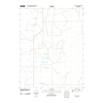
2010 Map of Box Springs
USGS Topo · Published 2010About this map
Box Springs serves as a central reference point in this high plains landscape, defined by a complex network of water management features and seasonal drainage. The area is characterized by an extensive series of impoundments, most notably the five sequentially numbered basins including Box Springs Reservoir Number 1 through Box Springs Reservoir Number 5. These reservoirs, along with South McCabe Lake and Reservoir Number 1, indicate the critical importance of water storage for the surrounding agricultural or ranching activities. The natural topography is further shaped by Horse Creek and Pond Creek, while the southwestern portion is marked by the distinctively named Dead Horse Creek. A rigid grid of county roads and section lines, such as County Road U and County Line 19, organizes the territory, reflecting the systematic land division typical of eastern Colorado.
Find a feature on this map
32 named features on this map. Tap any name to fly to it.
Don’t see what you’re looking for? This feature index may not catch every label — zoom into the map to look around manually.
Map Details
Editions of this 2010 Box Springs Map
This is the sole edition of this map. No revisions or reprints were ever made.
Other maps of this area

1889 · Sanborn
USGS Topo · 1:125,000

1891 · Sanborn
USGS Topo · 1:125,000

1891 · Catlin
USGS Topo · 1:125,000

1893 · Sanborn
USGS Topo · 1:125,000

1893 · Catlin
USGS Topo · 1:125,000

1954 · Lamar
USGS Topo · 1:250,000

1958 · Lamar
USGS Topo · 1:250,000

1977 · Walker Point
USGS Topo · 1:24,000
1977 · The Pinnacles
USGS Topo · 1:24,000
1977 · Box Springs
USGS Topo · 1:24,000