
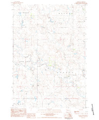
1983 Map of Boxcar Buttes
USGS Topo · Published 1984About this map
Grand River National Grassland dominates this portion of Perkins County, revealing a landscape defined by expansive open spaces and critical water resources during the early 1980s. The topographic relief is punctuated by the prominent Boxcar Buttes, which serve as a significant landmark in this high plains environment. The drainage pattern is established by several seasonal watercourses including Butcher Creek, Hart Creek, and Meadow Creek, which would have been vital for local ranching operations. The map delineates the Grassland Boundary, illustrating the division between public land and private holdings. Local place-name identifiers such as Independence, Rainbow, and Meadow indicate specific land units or neighborhood clusters. For researchers, the presence of various marked wells provides insight into the infrastructure required to sustain life and livestock in this arid region of South Dakota.
Find a feature on this map
10 named features on this map. Tap any name to fly to it.
Don’t see what you’re looking for? This feature index may not catch every label — zoom into the map to look around manually.
Map Details
Editions of this 1983 Boxcar Buttes Map
This is the sole edition of this map. No revisions or reprints were ever made.
Other maps of this area

1954 · Lemmon
USGS Topo · 1:250,000

1957 · Lemmon
USGS Topo · 1:250,000

1983 · Bison
USGS Topo · 1:24,000

1983 · Bison NE
USGS Topo · 1:24,000

1983 · Meadow NW
USGS Topo · 1:24,000

1983 · Meadow
USGS Topo · 1:24,000

1983 · Owen Lake
USGS Topo · 1:24,000

1983 · Coal Springs NW
USGS Topo · 1:24,000

1983 · Bison NW
USGS Topo · 1:24,000
1983 · Chance
USGS Topo · 1:24,000