
1983 Map of Bison
USGS Topo · Published 1984About this map
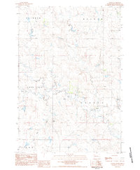
Bison serves as the focal point of this western South Dakota landscape, shown here as it transitioned into the early 1980s. The town's grid is clearly defined, featuring local infrastructure like the Radio Tower and Sewage Disp Ponds, while the nearby County Airport and Bison Cemetery ground the settlement's local history. The surrounding terrain is dominated by the Grand River National Grassland, with the South Fork Grand River cutting across the northern reaches of the quadrangle. Significant landmarks such as White Butte and the broad expanses of Marsh Field and Rainbow characterize the high plains topography. Water sources including Spring Creek and Thunder Butte Creek drain the undulating prairie, while scattered Well sites and a Gravel Pit indicate the light industrial and agricultural footprint of Perkins County during this period.
Find a feature on this map
20 named features on this map. Tap any name to fly to it.
Don’t see what you’re looking for? This feature index may not catch every label — zoom into the map to look around manually.
Map Details
Editions of this 1983 Bison Map
This is the sole edition of this map. No revisions or reprints were ever made.
Other maps of this area

1954 · Lemmon
USGS Topo · 1:250,000

1957 · Lemmon
USGS Topo · 1:250,000

1983 · Boxcar Buttes
USGS Topo · 1:24,000

1983 · Square Top Butte
USGS Topo · 1:24,000

1983 · Bison NE
USGS Topo · 1:24,000

1983 · Cole Dam
USGS Topo · 1:24,000

1983 · Date NE
USGS Topo · 1:24,000

1983 · Owen Lake
USGS Topo · 1:24,000

1983 · Bison NW
USGS Topo · 1:24,000
1983 · Chance
USGS Topo · 1:24,000