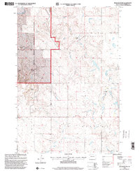
1998 Map of Boxcar Buttes
USGS Topo · Published 2001About this map
Grand River National Grassland dominates the western portion of this landscape, where the Grand River cuts a winding path through the prairie. In the late 20th century, this area of Perkins County remained characterized by isolated agricultural homesteads and distinct topographical landmarks. Notable family operations include the M Hulm Ranch, P Siedel Ranch, and G Williams Ranch, providing specific locations for genealogical research into the region's ranching history. The terrain is defined by the Boxcar Buttes and a network of drainages including Butcher Creek, Hart Creek, and Big Meadow Creek. These watercourses and named ranch sites reflect a sparse but established settlement pattern where land use was primarily dictated by the availability of water and grazing land.
Find a feature on this map
12 named features on this map. Tap any name to fly to it.
Don’t see what you’re looking for? This feature index may not catch every label — zoom into the map to look around manually.
Map Details
Editions of this 1998 Boxcar Buttes Map
This is the sole edition of this map. No revisions or reprints were ever made.
Other maps of this area

1954 · Lemmon
USGS Topo · 1:250,000

1957 · Lemmon
USGS Topo · 1:250,000

1983 · Boxcar Buttes
USGS Topo · 1:24,000

1983 · Bison
USGS Topo · 1:24,000

1983 · Bison NE
USGS Topo · 1:24,000

1983 · Meadow NW
USGS Topo · 1:24,000

1983 · Meadow
USGS Topo · 1:24,000

1983 · Owen Lake
USGS Topo · 1:24,000

1983 · Coal Springs NW
USGS Topo · 1:24,000

1983 · Bison NW
USGS Topo · 1:24,000