
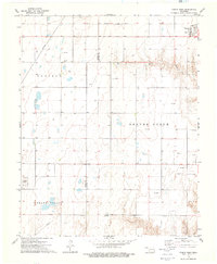
1973 Map of Boyd
USGS Topo · Published 1976About this map
Boyd serves as the central settlement in this portion of the Oklahoma Panhandle, situated along a landscape defined by energy extraction and intermittent watercourses. The 1973 survey highlights a sprawling Oil Field punctuated by numerous Gas Well and Oil Well sites, indicating the intense mid-century industrial footprint in Beaver County. The terrain is drained by Jackson Creek and Willow Creek, while the Beaver River cuts across the northwestern corner, its wide bed suggesting the seasonal fluctuations typical of the region. Local community life is anchored by landmarks such as Anthony Ch and Bethany Cem, which provide essential touchpoints for genealogical research. A prominent Radio Tower and various Gravel Pits further illustrate the infrastructure supporting this rural economy during the early 1970s.
Find a feature on this map
15 named features on this map. Tap any name to fly to it.
Don’t see what you’re looking for? This feature index may not catch every label — zoom into the map to look around manually.
Map Details
Editions of this 1973 Boyd Map
This is the sole edition of this map. No revisions or reprints were ever made.
Other maps of this area

1954 · Perryton
USGS Topo · 1:250,000

1958 · Perryton
USGS Topo · 1:250,000

1973 · Balko
USGS Topo · 1:24,000

1973 · Bryans Corner SW
USGS Topo · 1:24,000

1973 · Floris
USGS Topo · 1:24,000

1973 · Turpin East
USGS Topo · 1:24,000

1973 · Red Horse Creek
USGS Topo · 1:24,000

1973 · Bryans Corner
USGS Topo · 1:24,000

1973 · Balko SW
USGS Topo · 1:24,000
1973 · Turpin West
USGS Topo · 1:24,000