
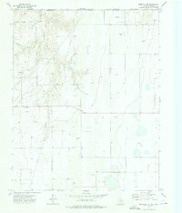
1973 Map of Bryans Corner SW
USGS Topo · Published 1976About this map
Beaver South and Hackberry regions of the Oklahoma Panhandle are defined here by a dense industrial network of extraction and energy infrastructure. Established in the 1970s, the Gas and Oil Field spans the rolling terrain, marked by a pervasive grid of Gas Wells, Oil Wells, and supporting facilities like a Compressor Station and Gas Plant. This landscape is bisected by the Texas Co Beaver Co boundary, where numerous Pipelines cut across natural drainage systems like Chiquita Creek and Fulton Creek. Despite the heavy industrial footprint, local landmarks persist, including the Pleasant Ridge Cem and a Roadside Park near the northern edge of the survey. The map provides an exacting record of the energy boom that transformed this portion of the High Plains, showing the precise placement of gravel and Caliche Pits alongside a Radio Tower.
Find a feature on this map
20 named features on this map. Tap any name to fly to it.
Don’t see what you’re looking for? This feature index may not catch every label — zoom into the map to look around manually.
Map Details
Editions of this 1973 Bryans Corner SW Map
This is the sole edition of this map. No revisions or reprints were ever made.
Other maps of this area

1954 · Perryton
USGS Topo · 1:250,000

1958 · Perryton
USGS Topo · 1:250,000

1968 · Hardesty SE
USGS Topo · 1:24,000

1968 · Hardesty NE
USGS Topo · 1:24,000

1973 · Horseshoe Hill
USGS Topo · 1:24,000

1973 · Boyd
USGS Topo · 1:24,000

1973 · Perryton
USGS Topo · 1:24,000

1973 · Red Horse Creek
USGS Topo · 1:24,000

1973 · Bryans Corner
USGS Topo · 1:24,000
1973 · Perryton NW
USGS Topo · 1:24,000