
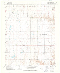
1968 Map of Hardesty NE
USGS Topo · Published 1969About this map
The North Canadian River meanders across this Oklahoma Panhandle landscape, where the planned inundation of the Optima Reservoir represents a significant transformation of the local hydrology. The survey reflects a region defined by energy extraction and transport, dominated by the extensive Hackberry Field and numerous Gas Wells scattered across the plains. The industrial footprint is further evidenced by a network of pipelines and the diagonal path of the Chicago Rock Island and Pacific railroad.
Find a feature on this map
16 named features on this map. Tap any name to fly to it.
Don’t see what you’re looking for? This feature index may not catch every label — zoom into the map to look around manually.
Map Details
Editions of this 1968 Hardesty NE Map
This is the sole edition of this map. No revisions or reprints were ever made.
Other maps of this area

1954 · Perryton
USGS Topo · 1:250,000

1958 · Perryton
USGS Topo · 1:250,000

1967 · Hooker
USGS Topo · 1:24,000

1967 · Adams
USGS Topo · 1:24,000

1968 · Hardesty
USGS Topo · 1:24,000

1968 · Optima Dam
USGS Topo · 1:24,000

1968 · Hardesty SE
USGS Topo · 1:24,000

1973 · Bryans Corner SW
USGS Topo · 1:24,000

1973 · Red Horse Creek
USGS Topo · 1:24,000
1973 · Turpin West
USGS Topo · 1:24,000