
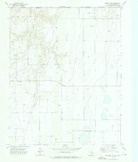
1968 Map of Hardesty SE
USGS Topo · Published 1969About this map
Palo Duro Creek winds through this panhandle landscape at the border of Oklahoma and Texas, where the high plains are carved by drainages like Hackberry Creek and Sand Draw. This late 1960s survey reveals an economy deeply tied to energy extraction, evidenced by the numerous Gas Wells and Oil Wells scattered across the township lines. Cultural life is anchored by small rural institutions such as Range Ch and the nearby Range Cem, alongside Bethel Ch further to the east. The presence of a Landing Field and an extensive Pipeline network underscores the logistical demands of this mid-century period. Notable water features like Webb Lake and the intermittent flows of Cottonwood Creek punctuate the arid terrain, while several Caliche Pits reflect the local geological materials used for road construction in the region.
Find a feature on this map
21 named features on this map. Tap any name to fly to it.
Don’t see what you’re looking for? This feature index may not catch every label — zoom into the map to look around manually.
Map Details
Editions of this 1968 Hardesty SE Map
This is the sole edition of this map. No revisions or reprints were ever made.
Other maps of this area

1954 · Perryton
USGS Topo · 1:250,000

1958 · Perryton
USGS Topo · 1:250,000

1962 · Hansford Camp
USGS Topo · 1:24,000

1968 · Hardesty
USGS Topo · 1:24,000

1968 · Optima Dam
USGS Topo · 1:24,000

1968 · Hardesty NE
USGS Topo · 1:24,000

1973 · Horseshoe Hill
USGS Topo · 1:24,000

1973 · Bryans Corner SW
USGS Topo · 1:24,000

1973 · Red Horse Creek
USGS Topo · 1:24,000
1973 · Perryton NW
USGS Topo · 1:24,000