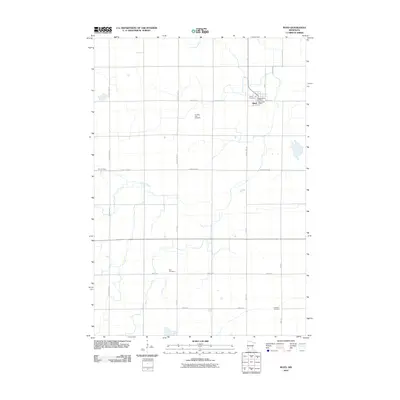
2010 Map of Boyd
USGS Topo · Published 2010About this map
Boyd serves as the primary hub of this Lac qui Parle County landscape, situated at the intersection of several regional routes including County Hwy-2 and County Hwy-29. The town's grid is anchored by the Boyd Post Office and Trinity Cemetery, reflecting a well-established rural community in the early 21st century. Beyond the town limits, the landscape is defined by a precise section-line road network including 350th St and 250th Ave, which connect a series of significant burial grounds. These sites, such as Ten Mile Lake Cemetery, Zion Cemetery, and Fridhem Cemetery, offer vital touchpoints for genealogists tracing family history in the Minnesota prairie. The winding path of Tenmile Creek provides the only major break in the agricultural grid, cutting across the western and northern portions of the quadrangle.
Find a feature on this map
20 named features on this map. Tap any name to fly to it.
Don’t see what you’re looking for? This feature index may not catch every label — zoom into the map to look around manually.
Map Details
Editions of this 2010 Boyd Map
This is the sole edition of this map. No revisions or reprints were ever made.
Other maps of this area

1953 · Watertown
USGS Topo · 1:250,000

1953 · New Ulm
USGS Topo · 1:250,000

1957 · New Ulm
USGS Topo · 1:250,000

1958 · New Ulm
USGS Topo · 1:250,000

1958 · Watertown
USGS Topo · 1:250,000

1965 · Clarkfield
USGS Topo · 1:24,000
1965 · Clarkfield NE
USGS Topo · 1:24,000
1965 · Tenmile Lake
USGS Topo · 1:24,000

1965 · Boyd
USGS Topo · 1:24,000

1967 · New Ulm
USGS Topo · 1:250,000