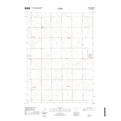
2018 Map of Boyden
USGS Topo · Published 2018About this map
Boyden and Hull anchor this section of Sioux County, where the agricultural grid is defined by a rigorous network of section-line roads. The landscape is primarily shaped by the W Br Floyd River, which meanders through the eastern and southern portions of the quadrangle, and Burr Oak Cr in the northwest. Local history and genealogy are well-represented by several burial grounds established near early church sites, including the Saint Pauls Evangelical Lutheran Cem and Saint John Cem in the north, and the Boyden Cem situated just outside the town limits. The towns themselves show the classic development of prairie settlements, with Boyden's street grid featuring names like Railroad St and Pleasant St, while Hull sits at the western edge along Black Forest Rd.
Find a feature on this map
38 named features on this map. Tap any name to fly to it.
Don’t see what you’re looking for? This feature index may not catch every label — zoom into the map to look around manually.
Map Details
Editions of this 2018 Boyden Map
This is the sole edition of this map. No revisions or reprints were ever made.
Other maps of this area
1954 · Fairmont
USGS Topo · 1:250,000
1955 · Sioux Falls
USGS Topo · 1:250,000
1958 · Sioux Falls
USGS Topo · 1:250,000
1958 · Fairmont
USGS Topo · 1:250,000
1964 · Hospers
USGS Topo · 1:24,000
1964 · Matlock
USGS Topo · 1:24,000
1964 · Orange City
USGS Topo · 1:24,000
1964 · Boyden
USGS Topo · 1:24,000
1964 · Sioux Center
USGS Topo · 1:24,000
1964 · Hull
USGS Topo · 1:24,000