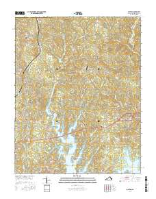
2016 Map of Boydton
USGS Topo · Published 2016About this map
Boydton serves as the focal point of this Mecklenburg County landscape, situated just north of the expansive John H. Kerr Reservoir. The terrain is defined by a dense network of small waterways, including Butcher Cr, Allen Cr, and Coleman Cr, which flow through the undulating countryside toward the reservoir. These drainage patterns influenced the early settlement and road networks of the region, connecting the primary town with outlying communities like Skipwith and Finchley. Local history is preserved through scattered rural landmarks such as New Hope Cem, Liberty Cem, and Saint Pauls Cem, which mark established family and church sites. The presence of Murdock's Holly Bu Airport reflects the continued utility of the land, while numerous named roads like Skipwith Rd and Puryears Store Rd follow historical routes across the Piedmont landscape.
Find a feature on this map
64 named features on this map. Tap any name to fly to it.
Don’t see what you’re looking for? This feature index may not catch every label — zoom into the map to look around manually.
Map Details
Editions of this 2016 Boydton Map
This is the sole edition of this map. No revisions or reprints were ever made.
Other maps of this area

1941 · Clarksville
USGS Topo · 1:48,000

1943 · Clarksville
USGS Topo · 1:62,500

1953 · Greensboro
USGS Topo · 1:250,000

1954 · Greensboro
USGS Topo · 1:250,000

1954 · Clover
USGS Topo · 1:62,500

1955 · Chase City
USGS Topo · 1:62,500

1955 · Boydton
USGS Topo · 1:62,500

1957 · Clarksville
USGS Topo · 1:62,500

1962 · Greensboro
USGS Topo · 1:250,000

1966 · Greensboro
USGS Topo · 1:250,000