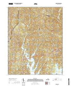
2019 Map of Boydton
USGS Topo · Published 2019About this map
Boydton serves as a focal point for this section of Mecklenburg County, where the Mecklenburg County Courthouse stands at the center of the local road network. The landscape is defined by the northern reaches of the John H. Kerr Reservoir, which fills the deep valleys of major tributaries like Butcher Creek and Eastland Cr. This geography creates a series of branching peninsulas that separate small rural communities and family-named landmarks. To the northwest, the settlement of Skipwith is situated near several cemeteries, including New Hope Cem and Liberty Cem, while Finchley marks a point along the southern highway corridor. The transition from agricultural land to the water's edge is punctuated by unique local features such as the Murdock's Holly Bu Airport and the Murdocks Flying V, illustrating a mix of traditional rural living and private aviation infrastructure.
Find a feature on this map
67 named features on this map. Tap any name to fly to it.
Don’t see what you’re looking for? This feature index may not catch every label — zoom into the map to look around manually.
Map Details
Editions of this 2019 Boydton Map
This is the sole edition of this map. No revisions or reprints were ever made.
Other maps of this area

1941 · Clarksville
USGS Topo · 1:48,000

1943 · Clarksville
USGS Topo · 1:62,500

1953 · Greensboro
USGS Topo · 1:250,000

1954 · Greensboro
USGS Topo · 1:250,000

1954 · Clover
USGS Topo · 1:62,500

1955 · Chase City
USGS Topo · 1:62,500

1955 · Boydton
USGS Topo · 1:62,500

1957 · Clarksville
USGS Topo · 1:62,500

1962 · Greensboro
USGS Topo · 1:250,000

1966 · Greensboro
USGS Topo · 1:250,000