
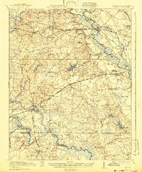
1920 Map of Boykins
USGS Topo · Published 1920About this map
Southampton County land use in the late 1910s centers on the fertile but difficult drainages of the Nottoway River and Meherrin River. These river systems are bordered by expansive wetlands like Assamoosick Swamp and Tarrara Swamp, which dictated the layout of early rural roads and rail lines. The Southern Railway and Seaboard Air Line provide the primary infrastructure for agricultural transport, linking the settlements of Newsoms, Boykins, and the county seat of Courtland.
Find a feature on this map
80 named features on this map. Tap any name to fly to it.
Don’t see what you’re looking for? This feature index may not catch every label — zoom into the map to look around manually.
Map Details
Editions of this 1920 Boykins Map
2 editions found
Other maps of this area

1908 · Winton
USGS Topo · 1:62,500

1919 · Jarratt
USGS Topo · 1:62,500

1919 · Homeville
USGS Topo · 1:48,000

1919 · Boykins
USGS Topo · 1:48,000

1919 · Arringdale
USGS Topo · 1:48,000

1920 · Holland
USGS Topo · 1:62,500

1920 · Ivor
USGS Topo · 1:62,500

1920 · Homeville
USGS Topo · 1:62,500

1920 · Arringdale
USGS Topo · 1:62,500

1942 · Arringdale
USGS Topo · 1:62,500