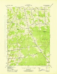
1943 Map of Boylston
USGS Topo · Published 1943About this map
Boylston Center and its surrounding rural hamlets are mapped here during the early 1940s, a time when this section of the Tug Hill region was defined by small-scale farming and the conservation efforts of the Littlejohn State Game Refuge. The landscape is etched by a dense network of waterways including Sandy Creek, Fox Creek, and Trout Brook, which dictated the placement of early settlements and road crossings. A remarkable number of local schoolhouses are visible, from School No 4 near Winona to School No 13 on Diamond Road, indicating a dispersed but active population. The terrain reflects the transition from open farmland to more heavily wooded areas, with many roads like Vorea Road and Smartville Road connecting family landmarks like Frederick Corner and La Plants Corners. Genealogists will find particular value in the placement of these schools and the St Joseph Cem near Smartville.
Find a feature on this map
57 named features on this map. Tap any name to fly to it.
Don’t see what you’re looking for? This feature index may not catch every label — zoom into the map to look around manually.
Map Details
Editions of this 1943 Boylston Map
This is the sole edition of this map. No revisions or reprints were ever made.
Other maps of this area

1893 · Sackets Harbor
USGS Topo · 1:62,500

1895 · Sacketts Harbor
USGS Topo · 1:62,500

1895 · Pulaski
USGS Topo · 1:62,500

1895 · Watertown
USGS Topo · 1:62,500

1898 · Watertown
USGS Topo · 1:62,500

1903 · Orwell
USGS Topo · 1:62,500

1905 · Orwell
USGS Topo · 1:62,500

1908 · Watertown
USGS Topo · 1:62,500

1909 · Watertown
USGS Topo · 1:62,500

1942 · Sandy Creek
USGS Topo · 1:24,000