
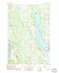
1975 Map of Boyne City NE
USGS Topo · Published 1976About this map
Lake Charlevoix dominates the northern reaches of this mid-1970s orthophotograph, providing a clear visual record of the shoreline and settlement patterns in Charlevoix County. This specific imagery, derived from a 1975 aerial flight, highlights the developed urban grid of Boyne City where the lake narrows at its eastern end, contrasted against the deeply wooded and agricultural terrain of the surrounding hills. In the southwest corner, the growing footprint of East Jordan is visible along the South Arm of the lake. The orthophoto format reveals the precise texture of the land—from individual farm clearings and timbered ridges to the expanding road networks connecting these Michigan lakeside communities. It captures a moment of transition, documenting the balance between industrial sites, residential expansion, and the natural timberlands during the mid-seventies.
Find a feature on this map
3 named features on this map. Tap any name to fly to it.
Don’t see what you’re looking for? This feature index may not catch every label — zoom into the map to look around manually.
Map Details
Editions of this 1975 Boyne City NE Map
This is the sole edition of this map. No revisions or reprints were ever made.
Other maps of this area

1955 · Cheboygan
USGS Topo · 1:250,000

1958 · Cheboygan
USGS Topo · 1:250,000

1958 · Bayshore
USGS Topo · 1:62,500

1958 · Petoskey
USGS Topo · 1:62,500

1961 · Boyne Falls
USGS Topo · 1:62,500

1961 · Boyne City
USGS Topo · 1:62,500

1975 · Boyne City NW
USGS Topo · 1:24,000

1975 · Petoskey SW
USGS Topo · 1:24,000

1982 · Petoskey
USGS Topo · 1:100,000
1983 · Ellsworth
USGS Topo · 1:25,000