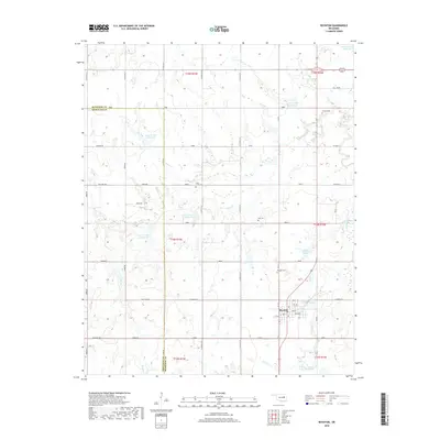
2018 Map of Boynton
USGS Topo · Published 2018About this map
Boynton serves as the primary hub of this eastern Oklahoma landscape, situated at the boundary of Muskogee County and Okmulgee County. The town's grid is detailed with streets like Lucille and Miller, anchored by the local Po (Post Office) and bordered by the Boynton Cemetery. Outside the town center, the terrain is defined by a sophisticated water management network of reservoirs, including Cane Creek Site 19 Reservoir and Cane Creek Site 20 Reservoir, which help control the drainage of Cane Creek and its tributaries.
Find a feature on this map
55 named features on this map. Tap any name to fly to it.
Don’t see what you’re looking for? This feature index may not catch every label — zoom into the map to look around manually.
Map Details
Editions of this 2018 Boynton Map
This is the sole edition of this map. No revisions or reprints were ever made.
Other maps of this area

1896 · Okmulgee
USGS Topo · 1:125,000

1900 · Okmulgee
USGS Topo · 1:125,000

1946 · Fort Smith
USGS Topo · 1:250,000

1965 · Fort Smith
USGS Topo · 1:250,000

1967 · Fort Smith
USGS Topo · 1:250,000
1970 · Wainwright
USGS Topo · 1:24,000
1970 · Council Hill
USGS Topo · 1:24,000
1970 · Morris
USGS Topo · 1:24,000
1971 · Beland
USGS Topo · 1:24,000
1971 · Okmulgee NE
USGS Topo · 1:24,000