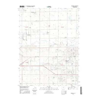
2016 Map of Bracewell
USGS Topo · Published 2016About this map
Greeley and Evans anchor the southeastern corner of this landscape, where the urban street grid meets the complex irrigation networks of the High Plains. The Cache la Poudre River winds through the center of the quadrangle, flanked by numerous engineered waterways like the Greeley Number 2 Canal and Greeley Number 3 Ditch that sustain local agriculture. Smaller settlements such as Severance, Windsor, and Bracewell are interspersed among agricultural tracts, with notable landmarks like Antelope Hill and the Highline Farm Airstrip rising from the terrain. The presence of Aims Community Coll indicates the area's modern educational infrastructure, while reservoirs such as Neff Lake and Hogarty Reservoir reflect the critical importance of water management in Weld County's development.
Find a feature on this map
148 named features on this map. Tap any name to fly to it.
Don’t see what you’re looking for? This feature index may not catch every label — zoom into the map to look around manually.
Map Details
Editions of this 2016 Bracewell Map
This is the sole edition of this map. No revisions or reprints were ever made.
Other maps of this area

1902 · Greeley
USGS Topo · 1:125,000

1908 · Eaton
USGS Topo · 1:125,000

1910 · Eaton
USGS Topo · 1:125,000

1950 · Greeley
USGS Topo · 1:24,000

1950 · Windsor
USGS Topo · 1:24,000

1950 · Johnstown
USGS Topo · 1:24,000

1950 · Bracewell
USGS Topo · 1:24,000

1950 · Milliken
USGS Topo · 1:24,000

1950 · La Salle
USGS Topo · 1:24,000
1951 · Johnstown
USGS Topo · 1:24,000