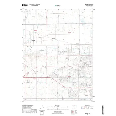
2019 Map of Bracewell
USGS Topo · Published 2019About this map
The Cache la Poudre River winds through this landscape northwest of Greeley, defining a region shaped by complex irrigation and early 21st-century growth. Traces of the area's agricultural foundation are visible in the dense network of water features, including the Greeley Number 2 Canal, Greeley Number 3 Ditch, and the Loveland and Greeley Canal. These systems support the surrounding plains and livestock operations, evidenced by features like the Highline Farm Airstrip. Small agricultural communities and sidings such as Severance, Bracewell, and Farmers dot the map, many linked by the historic path of the Great Western RR. To the south, the expansion of Evans and the sprawling campus of Aims Community College illustrate the urban development encroaching upon the traditional farmsteads and landmarks like Antelope Hill.
Find a feature on this map
109 named features on this map. Tap any name to fly to it.
Don’t see what you’re looking for? This feature index may not catch every label — zoom into the map to look around manually.
Map Details
Editions of this 2019 Bracewell Map
This is the sole edition of this map. No revisions or reprints were ever made.
Other maps of this area

1902 · Greeley
USGS Topo · 1:125,000

1908 · Eaton
USGS Topo · 1:125,000

1910 · Eaton
USGS Topo · 1:125,000

1950 · Greeley
USGS Topo · 1:24,000

1950 · Windsor
USGS Topo · 1:24,000

1950 · Johnstown
USGS Topo · 1:24,000

1950 · Bracewell
USGS Topo · 1:24,000

1950 · Milliken
USGS Topo · 1:24,000

1950 · La Salle
USGS Topo · 1:24,000
1951 · Johnstown
USGS Topo · 1:24,000