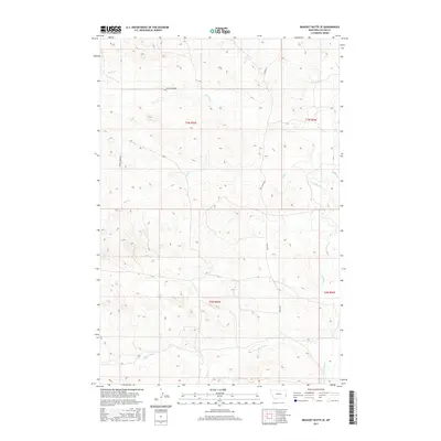
2017 Map of Bracket Butte SE
USGS Topo · Published 2017About this map
O'Fallon Cr and its network of tributaries define this eastern Montana landscape in the late 2010s, where the drainages of Miles City Cr and Hay Cr carve through the high plains. The map illustrates a remote ranching or agricultural environment structured by the Public Land Survey System, as evidenced by the clear township and range lines like t7n r55e and t6n r56e. Transportation in this portion of Fallon County relies on a sparse grid of local thoroughfares, including the north-south Ismay Rd S and the lateral Spring Creek Rd. These routes follow the natural topography, connecting isolated points across the undulating terrain near Spring Cr and Timber Cr. The drainage patterns, particularly around Back Cr, offer a detailed look at the water-carved geography that has historically dictated settlement and movement in this part of the state.
Find a feature on this map
13 named features on this map. Tap any name to fly to it.
Don’t see what you’re looking for? This feature index may not catch every label — zoom into the map to look around manually.
Map Details
Editions of this 2017 Bracket Butte SE Map
This is the sole edition of this map. No revisions or reprints were ever made.
Other maps of this area

1953 · Miles City
USGS Topo · 1:250,000

1957 · Miles City
USGS Topo · 1:250,000

1958 · Miles City
USGS Topo · 1:250,000

1981 · Baker
USGS Topo · 1:100,000

1981 · Harmon Butte
USGS Topo · 1:24,000
1981 · Bracket Butte
USGS Topo · 1:24,000

1981 · Nelson Butte
USGS Topo · 1:24,000

1981 · Bracket Butte SE
USGS Topo · 1:24,000
1981 · Hooky Dam
USGS Topo · 1:24,000
1981 · Ismay South
USGS Topo · 1:24,000