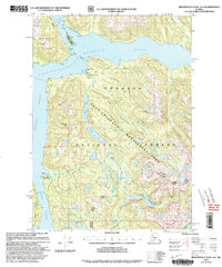
2000 Map of Bradfield Canal A-6
USGS Topo · Published 2003About this map
The remote Alaskan coastlines of Bradfield Canal and Ernest Sound define this wilderness survey, which highlights the conservation and management efforts within the Tongass National Forest. The map focuses heavily on the Anan Creek LUD II Management Area, a region characterized by its freshwater systems including Anan Lake and Boulder Lake. Forest Service infrastructure is prominent, noting specific sites such as the Anan Bear Observatory (FS) and several remote outposts like Anan Bay Cabin (FS) and the Frosty Bay Cabin (FS).
Find a feature on this map
34 named features on this map. Tap any name to fly to it.
Don’t see what you’re looking for? This feature index may not catch every label — zoom into the map to look around manually.
Map Details
Editions of this 2000 Bradfield Canal A-6 Map
This is the sole edition of this map. No revisions or reprints were ever made.
Other maps of this area

1948 · Petersburg A-1
USGS Topo · 1:63,360

1948 · Petersburg B-1
USGS Topo · 1:63,360

1949 · Craig D-1
USGS Topo · 1:63,360

1951 · Bradfield Canal
USGS Topo · 1:250,000

1951 · Craig D-1
USGS Topo · 1:63,360

1951 · Petersburg A-1
USGS Topo · 1:63,360

1952 · Petersburg
USGS Topo · 1:250,000

1952 · Ketchikan
USGS Topo · 1:250,000

1952 · Ketchikan D-5
USGS Topo · 1:63,360

1952 · Ketchikan D-6
USGS Topo · 1:63,360