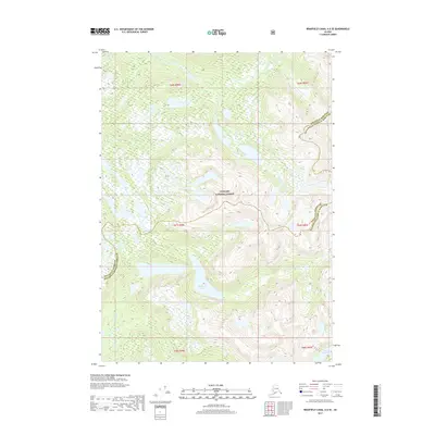
2017 Map of Bradfield Canal A-6 SE
USGS Topo · Published 2017About this map
Tongass National Forest dominates this Alaskan landscape, where the administrative boundary between the Wrangell Borough and Ketchikan Gateway Borough bisects the terrain. The hydrological network is defined by high-elevation catchments and drainages, most notably Anan Creek and its tributary, E Fork Anan Creek. Several prominent bodies of water are captured at this 2017 date, including the central Halfmoon Lake and the smaller Lake Rowena in the southeastern corner. The map provides precise topographic detail of the steep ridgelines and glacial valleys that characterize this part of the Alexander Archipelago, showing the drainage patterns of Walker Creek as it flows through the western portion of the quadrangle. This survey serves as a definitive record of the natural boundaries and wilderness survey lines within the Tongass region during the early 21st century.
Find a feature on this map
13 named features on this map. Tap any name to fly to it.
Don’t see what you’re looking for? This feature index may not catch every label — zoom into the map to look around manually.
Map Details
Editions of this 2017 Bradfield Canal A-6 SE Map
This is the sole edition of this map. No revisions or reprints were ever made.
Other maps of this area

1951 · Bradfield Canal
USGS Topo · 1:250,000

1952 · Ketchikan
USGS Topo · 1:250,000

1952 · Ketchikan D-5
USGS Topo · 1:63,360

1952 · Ketchikan D-6
USGS Topo · 1:63,360

1953 · Ketchikan D-5
USGS Topo · 1:63,360

1953 · Ketchikan D-6
USGS Topo · 1:63,360

1954 · Bradfield Canal
USGS Topo · 1:250,000

1955 · Bradfield canal A-6
USGS Topo · 1:63,360

1955 · Bradfield Canal A-5
USGS Topo · 1:63,360

1955 · Ketchikan
USGS Topo · 1:250,000