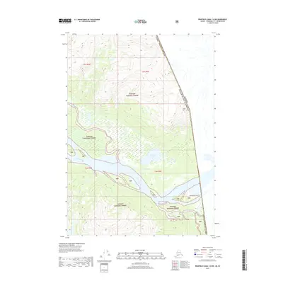
2017 Map of Bradfield Canal C-6 NW
USGS Topo · Published 2017About this map
Stikine River watercourses and shifting river channels dominate this portion of the Tongass National Forest along the international border between Alaska and Canada. The landscape is defined by the complex hydrology of the Ketili River and Kikahe River, where slow-moving waters form Guerin Slough and feed into Barnes Lake. The presence of named features like Cottonwood Island and Red Slough illustrates the alluvial nature of the valley floor, while Elbow Mtn provides a stark vertical contrast to the braided river systems below. This topography represents a classic North American coastal mountain boundary, where the heavy glaciation and runoff of the region have carved deep, water-rich corridors through the Tongass National Forest wilderness.
Find a feature on this map
19 named features on this map. Tap any name to fly to it.
Don’t see what you’re looking for? This feature index may not catch every label — zoom into the map to look around manually.
Map Details
Editions of this 2017 Bradfield Canal C-6 NW Map
This is the sole edition of this map. No revisions or reprints were ever made.
Other maps of this area

1948 · Petersburg C-1
USGS Topo · 1:63,360

1951 · Bradfield Canal
USGS Topo · 1:250,000

1952 · Petersburg
USGS Topo · 1:250,000

1953 · Petersburg C-1
USGS Topo · 1:63,360

1954 · Bradfield Canal
USGS Topo · 1:250,000

1955 · Bradfield canal D-6
USGS Topo · 1:63,360

1955 · Bradfield canal C-6
USGS Topo · 1:63,360

1955 · Bradfield Canal
USGS Topo · 1:250,000

1960 · Petersburg
USGS Topo · 1:250,000

1961 · Petersburg D-1
USGS Topo · 1:63,360