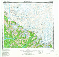
1955 Map of Bradfield Canal
USGS Topo · Published 1966About this map
Tongass National Forest dominates the southwestern portion of this mid-century survey, where the glacial landscape meets the intricate waterways of the Alaskan panhandle. The map documents the international boundary between Alaska and British Columbia, cutting through high peaks such as Snowcap Mtn and Mt Whipple. The glacial systems here are extensive, including the Hoodoo Glacier, Twin Glacier, and the Great Glacier, which feed into major arterial waterways like the Iskut River and Bradfield River.
Find a feature on this map
92 named features on this map. Tap any name to fly to it.
Don’t see what you’re looking for? This feature index may not catch every label — zoom into the map to look around manually.
Map Details
Editions of this 1955 Bradfield Canal Map
2 editions found
Historical Maps of Prince of Wales-Hyder Through Time
659 maps found

1948 Craig A-1
Prince of Wales-Hyder Borough, AK

1948 Craig A-2
Prince of Wales-Hyder Borough, AK

1948 Craig A-3
Prince of Wales-Hyder Borough, AK

1948 Craig A-4
Prince of Wales-Hyder Borough, AK

1948 Craig A-5
Prince of Wales-Hyder Borough, AK

1948 Craig B-5
Prince of Wales-Hyder Borough, AK

1948 Craig B-6
Prince of Wales-Hyder Borough, AK

1948 Dixon Entrance C-1
Prince of Wales-Hyder Borough, AK

1948 Dixon Entrance C-3
Prince of Wales-Hyder Borough, AK

1948 Dixon Entrance D-1
Prince of Wales-Hyder Borough, AK

1948 Dixon Entrance D-2
Prince of Wales-Hyder Borough, AK

1948 Dixon Entrance D-3
Prince of Wales-Hyder Borough, AK

1948 Dixon Entrance D-4
Prince of Wales-Hyder Borough, AK

1948 Dixon Entrance D-5
Prince of Wales-Hyder Borough, AK

1948 Ketchikan A-6
Prince of Wales-Hyder Borough, AK

1948 Petersburg A-2
Prince of Wales-Hyder Borough, AK

1948 Petersburg A-6
Prince of Wales-Hyder Borough, AK

1948 Petersburg B-3
Prince of Wales-Hyder Borough, AK

1948 Petersburg B-6
Prince of Wales-Hyder Borough, AK

1948 Prince Rupert D-6
Prince of Wales-Hyder Borough, AK

1949 Craig B-1
Prince of Wales-Hyder Borough, AK

1949 Craig B-2
Prince of Wales-Hyder Borough, AK

1949 Craig B-3
Prince of Wales-Hyder Borough, AK

1949 Craig B-4
Prince of Wales-Hyder Borough, AK

1949 Craig C-2
Prince of Wales-Hyder Borough, AK

1949 Craig C-3
Prince of Wales-Hyder Borough, AK

1949 Craig C-4
Prince of Wales-Hyder Borough, AK

1949 Craig D-1
Prince of Wales-Hyder Borough, AK

1949 Craig D-2
Prince of Wales-Hyder Borough, AK

1949 Craig D-3
Prince of Wales-Hyder Borough, AK

1949 Craig D-4
Prince of Wales-Hyder Borough, AK

1949 Ketchikan C-6
Prince of Wales-Hyder Borough, AK

1949 Petersburg A-3
Prince of Wales-Hyder Borough, AK

1949 Petersburg A-4
Prince of Wales-Hyder Borough, AK

1949 Petersburg A-5
Prince of Wales-Hyder Borough, AK

1949 Petersburg B-4
Prince of Wales-Hyder Borough, AK

1949 Petersburg B-5
Prince of Wales-Hyder Borough, AK

1950 Craig B-1
Prince of Wales-Hyder Borough, AK

1950 Craig C-1
Prince of Wales-Hyder Borough, AK

1950 Craig D-3
Prince of Wales-Hyder Borough, AK

1951 Bradfield Canal
Prince of Wales-Hyder Borough, AK

1951 Craig A-2
Prince of Wales-Hyder Borough, AK

1951 Craig A-3
Prince of Wales-Hyder Borough, AK

1951 Craig A-4
Prince of Wales-Hyder Borough, AK

1951 Craig B-2
Prince of Wales-Hyder Borough, AK

1951 Craig B-3
Prince of Wales-Hyder Borough, AK

1951 Craig B-4
Prince of Wales-Hyder Borough, AK

1951 Craig C-1
Prince of Wales-Hyder Borough, AK

1951 Craig C-2
Prince of Wales-Hyder Borough, AK

1951 Craig C-3
Prince of Wales-Hyder Borough, AK

1951 Craig C-4
Prince of Wales-Hyder Borough, AK

1951 Craig C-5
Prince of Wales-Hyder Borough, AK

1951 Craig C-6
Prince of Wales-Hyder Borough, AK

1951 Craig D-1
Prince of Wales-Hyder Borough, AK

1951 Craig D-2
Prince of Wales-Hyder Borough, AK

1951 Craig D-4
Prince of Wales-Hyder Borough, AK

1951 Craig D-5
Prince of Wales-Hyder Borough, AK

1951 Craig D-6
Prince of Wales-Hyder Borough, AK

1951 Dixon Entrance D-2
Prince of Wales-Hyder Borough, AK

1951 Dixon Entrance D-3
Prince of Wales-Hyder Borough, AK

1951 Dixon Entrance D-4
Prince of Wales-Hyder Borough, AK

1951 Dixon Entrance
Prince of Wales-Hyder Borough, AK

1951 Petersburg A-6
Prince of Wales-Hyder Borough, AK

1951 Petersburg B-3
Prince of Wales-Hyder Borough, AK

1951 Petersburg B-4
Prince of Wales-Hyder Borough, AK

1951 Petersburg B-6
Prince of Wales-Hyder Borough, AK

1951 Prince Rupert D-6
Prince of Wales-Hyder Borough, AK

1951 Prince Rupert
Prince of Wales-Hyder Borough, AK

1952 Ketchikan C-6
Prince of Wales-Hyder Borough, AK

1952 Ketchikan D-6
Prince of Wales-Hyder Borough, AK

1952 Petersburg
Prince of Wales-Hyder Borough, AK

1953 Ketchikan D-6
Prince of Wales-Hyder Borough, AK

1953 Petersburg A-2
Prince of Wales-Hyder Borough, AK

1953 Petersburg A-3
Prince of Wales-Hyder Borough, AK

1953 Petersburg A-4
Prince of Wales-Hyder Borough, AK

1953 Petersburg A-5
Prince of Wales-Hyder Borough, AK

1953 Petersburg B-5
Prince of Wales-Hyder Borough, AK

1954 Bradfield Canal
Prince of Wales-Hyder Borough, AK

1955 Bradfield Canal A-1
Prince of Wales-Hyder Borough, AK

1955 Bradfield canal A-2
Prince of Wales-Hyder Borough, AK

1955 Bradfield canal A-3
Prince of Wales-Hyder Borough, AK

1955 Bradfield canal A-4
Prince of Wales-Hyder Borough, AK

1955 Bradfield Canal A-5
Prince of Wales-Hyder Borough, AK

1955 Bradfield canal A-6
Prince of Wales-Hyder Borough, AK

1955 Bradfield canal B-2
Prince of Wales-Hyder Borough, AK

1955 Bradfield canal B-3
Prince of Wales-Hyder Borough, AK

1955 Bradfield canal B-4
Prince of Wales-Hyder Borough, AK

1955 Bradfield Canal
Prince of Wales-Hyder Borough, AK

1955 Ketchikan A-1
Prince of Wales-Hyder Borough, AK

1955 Ketchikan A-2
Prince of Wales-Hyder Borough, AK

1955 Ketchikan A-3
Prince of Wales-Hyder Borough, AK

1955 Ketchikan A-4
Prince of Wales-Hyder Borough, AK

1955 Ketchikan A-5
Prince of Wales-Hyder Borough, AK

1955 Ketchikan B-1
Prince of Wales-Hyder Borough, AK

1955 Ketchikan B-2
Prince of Wales-Hyder Borough, AK

1955 Ketchikan B-3
Prince of Wales-Hyder Borough, AK

1955 Ketchikan C-1
Prince of Wales-Hyder Borough, AK

1955 Ketchikan C-2
Prince of Wales-Hyder Borough, AK

1955 Ketchikan C-3
Prince of Wales-Hyder Borough, AK

1955 Ketchikan D-1
Prince of Wales-Hyder Borough, AK

1955 Ketchikan D-2
Prince of Wales-Hyder Borough, AK

1955 Ketchikan D-3
Prince of Wales-Hyder Borough, AK

1955 Prince Rupert D-1
Prince of Wales-Hyder Borough, AK

1955 Prince Rupert D-2
Prince of Wales-Hyder Borough, AK

1955 Prince Rupert D-3
Prince of Wales-Hyder Borough, AK

1955 Prince Rupert D-4
Prince of Wales-Hyder Borough, AK

1955 Prince Rupert D-5
Prince of Wales-Hyder Borough, AK

1958 Prince Rupert C-2 and C-3
Prince of Wales-Hyder Borough, AK

1959 Dixon Entrance
Prince of Wales-Hyder Borough, AK

1959 Prince Rupert
Prince of Wales-Hyder Borough, AK

1960 Petersburg
Prince of Wales-Hyder Borough, AK

1964 Prince Rupert
Prince of Wales-Hyder Borough, AK

1973 Bradfield Canal B-2
Prince of Wales-Hyder Borough, AK

1994 Craig A-4
Prince of Wales-Hyder Borough, AK

1994 Craig C-2
Prince of Wales-Hyder Borough, AK

1994 Craig C-3
Prince of Wales-Hyder Borough, AK

1994 Craig D-2
Prince of Wales-Hyder Borough, AK

1994 Craig D-3
Prince of Wales-Hyder Borough, AK

1994 Craig D-4
Prince of Wales-Hyder Borough, AK

1994 Dixon Entrance C-3
Prince of Wales-Hyder Borough, AK

1994 Dixon Entrance D-1
Prince of Wales-Hyder Borough, AK

1994 Petersburg A-3
Prince of Wales-Hyder Borough, AK

1994 Petersburg A-4
Prince of Wales-Hyder Borough, AK

1995 Bradfield Canal A-4
Prince of Wales-Hyder Borough, AK

1995 Ketchikan C-6
Prince of Wales-Hyder Borough, AK

1995 Petersburg A-2
Prince of Wales-Hyder Borough, AK

1995 Petersburg A-5
Prince of Wales-Hyder Borough, AK

1995 Petersburg B-3
Prince of Wales-Hyder Borough, AK

1995 Petersburg B-4
Prince of Wales-Hyder Borough, AK

1995 Petersburg B-5
Prince of Wales-Hyder Borough, AK

1996 Bradfield Canal A-1
Prince of Wales-Hyder Borough, AK

1996 Craig A-2
Prince of Wales-Hyder Borough, AK

1996 Craig D-5
Prince of Wales-Hyder Borough, AK

1996 Ketchikan C-2
Prince of Wales-Hyder Borough, AK

1996 Ketchikan C-3
Prince of Wales-Hyder Borough, AK

1996 Ketchikan D-2
Prince of Wales-Hyder Borough, AK

1996 Ketchikan D-3
Prince of Wales-Hyder Borough, AK

1997 Bradfield Canal A-1
Prince of Wales-Hyder Borough, AK

1997 Craig A-1
Prince of Wales-Hyder Borough, AK

1997 Craig A-3
Prince of Wales-Hyder Borough, AK

1997 Craig B-2
Prince of Wales-Hyder Borough, AK

2000 Bradfield Canal A-1
Prince of Wales-Hyder Borough, AK

2000 Bradfield Canal A-2
Prince of Wales-Hyder Borough, AK

2000 Bradfield Canal A-6
Prince of Wales-Hyder Borough, AK

2000 Craig B-5
Prince of Wales-Hyder Borough, AK

2000 Craig B-6
Prince of Wales-Hyder Borough, AK

2000 Craig D-1
Prince of Wales-Hyder Borough, AK

2000 Ketchikan D-6
Prince of Wales-Hyder Borough, AK

2017 Bradfield Canal A-4 NE
Prince of Wales-Hyder Borough, AK

2017 Bradfield Canal A-4 NW
Prince of Wales-Hyder Borough, AK

2017 Bradfield Canal A-4 SE
Prince of Wales-Hyder Borough, AK

2017 Bradfield Canal A-4 SW
Prince of Wales-Hyder Borough, AK

2017 Bradfield Canal A-5 NE
Prince of Wales-Hyder Borough, AK

2017 Bradfield Canal A-5 SE
Prince of Wales-Hyder Borough, AK

2017 Bradfield Canal A-5 SW
Prince of Wales-Hyder Borough, AK

2017 Bradfield Canal A-6 SE
Prince of Wales-Hyder Borough, AK

2017 Bradfield Canal A-6 SW
Prince of Wales-Hyder Borough, AK

2017 Bradfield Canal B-4 NE
Prince of Wales-Hyder Borough, AK

2017 Bradfield Canal B-4 SE
Prince of Wales-Hyder Borough, AK

2017 Craig A-1 NE
Prince of Wales-Hyder Borough, AK

2017 Craig A-1 NW
Prince of Wales-Hyder Borough, AK

2017 Craig A-1 SE
Prince of Wales-Hyder Borough, AK

2017 Craig A-1 SW
Prince of Wales-Hyder Borough, AK

2017 Craig A-2 NE
Prince of Wales-Hyder Borough, AK

2017 Craig A-2 NW
Prince of Wales-Hyder Borough, AK

2017 Craig A-2 SE
Prince of Wales-Hyder Borough, AK

2017 Craig A-2 SW
Prince of Wales-Hyder Borough, AK

2017 Craig A-3 NE
Prince of Wales-Hyder Borough, AK

2017 Craig A-3 NW
Prince of Wales-Hyder Borough, AK

2017 Craig A-3 SE
Prince of Wales-Hyder Borough, AK

2017 Craig A-3 SW
Prince of Wales-Hyder Borough, AK

2017 Craig A-4 NE
Prince of Wales-Hyder Borough, AK

2017 Craig A-4 NW
Prince of Wales-Hyder Borough, AK

2017 Craig A-4 SE
Prince of Wales-Hyder Borough, AK

2017 Craig A-4 SW
Prince of Wales-Hyder Borough, AK

2017 Craig A-5 NE
Prince of Wales-Hyder Borough, AK

2017 Craig A-5 NW
Prince of Wales-Hyder Borough, AK

2017 Craig B-1 NE
Prince of Wales-Hyder Borough, AK

2017 Craig B-1 NW
Prince of Wales-Hyder Borough, AK

2017 Craig B-1 SE
Prince of Wales-Hyder Borough, AK

2017 Craig B-1 SW
Prince of Wales-Hyder Borough, AK

2017 Craig B-2 NE
Prince of Wales-Hyder Borough, AK

2017 Craig B-2 NW
Prince of Wales-Hyder Borough, AK

2017 Craig B-2 SE
Prince of Wales-Hyder Borough, AK

2017 Craig B-2 SW
Prince of Wales-Hyder Borough, AK

2017 Craig B-3 NE
Prince of Wales-Hyder Borough, AK

2017 Craig B-3 NW
Prince of Wales-Hyder Borough, AK

2017 Craig B-3 SE
Prince of Wales-Hyder Borough, AK

2017 Craig B-3 SW
Prince of Wales-Hyder Borough, AK

2017 Craig B-4 NE
Prince of Wales-Hyder Borough, AK

2017 Craig B-4 NW
Prince of Wales-Hyder Borough, AK

2017 Craig B-4 SE
Prince of Wales-Hyder Borough, AK

2017 Craig B-4 SW
Prince of Wales-Hyder Borough, AK

2017 Craig B-5 NE
Prince of Wales-Hyder Borough, AK

2017 Craig B-5 NW
Prince of Wales-Hyder Borough, AK

2017 Craig B-5 SE
Prince of Wales-Hyder Borough, AK

2017 Craig B-5 SW
Prince of Wales-Hyder Borough, AK

2017 Craig B-6 NE
Prince of Wales-Hyder Borough, AK

2017 Craig B-6 SE
Prince of Wales-Hyder Borough, AK

2017 Craig C-1 NE
Prince of Wales-Hyder Borough, AK

2017 Craig C-1 NW
Prince of Wales-Hyder Borough, AK

2017 Craig C-1 SE
Prince of Wales-Hyder Borough, AK

2017 Craig C-1 SW
Prince of Wales-Hyder Borough, AK

2017 Craig C-2 NE
Prince of Wales-Hyder Borough, AK

2017 Craig C-2 NW
Prince of Wales-Hyder Borough, AK

2017 Craig C-2 SE
Prince of Wales-Hyder Borough, AK

2017 Craig C-2 SW
Prince of Wales-Hyder Borough, AK

2017 Craig C-3 NE
Prince of Wales-Hyder Borough, AK

2017 Craig C-3 NW
Prince of Wales-Hyder Borough, AK

2017 Craig C-3 SE
Prince of Wales-Hyder Borough, AK

2017 Craig C-3 SW
Prince of Wales-Hyder Borough, AK

2017 Craig C-4 NE
Prince of Wales-Hyder Borough, AK

2017 Craig C-4 NW
Prince of Wales-Hyder Borough, AK

2017 Craig C-4 SE
Prince of Wales-Hyder Borough, AK

2017 Craig C-4 SW
Prince of Wales-Hyder Borough, AK

2017 Craig C-5 NE
Prince of Wales-Hyder Borough, AK

2017 Craig C-5 NW
Prince of Wales-Hyder Borough, AK

2017 Craig C-5 SE
Prince of Wales-Hyder Borough, AK

2017 Craig C-5 SW
Prince of Wales-Hyder Borough, AK

2017 Craig C-6 SE
Prince of Wales-Hyder Borough, AK

2017 Craig D-1 NE
Prince of Wales-Hyder Borough, AK

2017 Craig D-1 NW
Prince of Wales-Hyder Borough, AK

2017 Craig D-1 SE
Prince of Wales-Hyder Borough, AK

2017 Craig D-1 SW
Prince of Wales-Hyder Borough, AK

2017 Craig D-2 NE
Prince of Wales-Hyder Borough, AK

2017 Craig D-2 NW
Prince of Wales-Hyder Borough, AK

2017 Craig D-2 SE
Prince of Wales-Hyder Borough, AK

2017 Craig D-2 SW
Prince of Wales-Hyder Borough, AK

2017 Craig D-3 NE
Prince of Wales-Hyder Borough, AK

2017 Craig D-3 NW
Prince of Wales-Hyder Borough, AK

2017 Craig D-3 SE
Prince of Wales-Hyder Borough, AK

2017 Craig D-3 SW
Prince of Wales-Hyder Borough, AK

2017 Craig D-4 NE
Prince of Wales-Hyder Borough, AK

2017 Craig D-4 NW
Prince of Wales-Hyder Borough, AK

2017 Craig D-4 SE
Prince of Wales-Hyder Borough, AK

2017 Craig D-4 SW
Prince of Wales-Hyder Borough, AK

2017 Craig D-5 NE
Prince of Wales-Hyder Borough, AK

2017 Craig D-5 NW
Prince of Wales-Hyder Borough, AK

2017 Craig D-5 SE
Prince of Wales-Hyder Borough, AK

2017 Craig D-5 SW
Prince of Wales-Hyder Borough, AK

2017 Craig D-6 NE
Prince of Wales-Hyder Borough, AK

2017 Craig D-6 NW
Prince of Wales-Hyder Borough, AK

2017 Craig D-6 SE
Prince of Wales-Hyder Borough, AK

2017 Craig D-6 SW
Prince of Wales-Hyder Borough, AK

2017 Dixon Entrance C-1 NE
Prince of Wales-Hyder Borough, AK

2017 Dixon Entrance C-1 NW
Prince of Wales-Hyder Borough, AK

2017 Dixon Entrance C-3 NE
Prince of Wales-Hyder Borough, AK

2017 Dixon Entrance C-3 NW
Prince of Wales-Hyder Borough, AK

2017 Dixon Entrance D-1 NE
Prince of Wales-Hyder Borough, AK

2017 Dixon Entrance D-1 NW
Prince of Wales-Hyder Borough, AK

2017 Dixon Entrance D-1 SE
Prince of Wales-Hyder Borough, AK

2017 Dixon Entrance D-1 SW
Prince of Wales-Hyder Borough, AK

2017 Dixon Entrance D-2 NE
Prince of Wales-Hyder Borough, AK

2017 Dixon Entrance D-2 NW
Prince of Wales-Hyder Borough, AK

2017 Dixon Entrance D-2 SE
Prince of Wales-Hyder Borough, AK

2017 Dixon Entrance D-2 SW
Prince of Wales-Hyder Borough, AK

2017 Dixon Entrance D-3 NE
Prince of Wales-Hyder Borough, AK

2017 Dixon Entrance D-3 NW
Prince of Wales-Hyder Borough, AK

2017 Dixon Entrance D-3 SE
Prince of Wales-Hyder Borough, AK

2017 Dixon Entrance D-3 SW
Prince of Wales-Hyder Borough, AK

2017 Ketchikan A-4 NE
Prince of Wales-Hyder Borough, AK

2017 Ketchikan A-4 NW
Prince of Wales-Hyder Borough, AK

2017 Ketchikan A-4 SE
Prince of Wales-Hyder Borough, AK

2017 Ketchikan A-4 SW
Prince of Wales-Hyder Borough, AK

2017 Ketchikan A-5 NE
Prince of Wales-Hyder Borough, AK

2017 Ketchikan A-5 NW
Prince of Wales-Hyder Borough, AK

2017 Ketchikan A-5 SE
Prince of Wales-Hyder Borough, AK

2017 Ketchikan A-5 SW
Prince of Wales-Hyder Borough, AK

2017 Ketchikan A-6 NW
Prince of Wales-Hyder Borough, AK

2017 Ketchikan A-6 SW
Prince of Wales-Hyder Borough, AK

2017 Ketchikan C-6 NW
Prince of Wales-Hyder Borough, AK

2017 Ketchikan D-4 NE
Prince of Wales-Hyder Borough, AK

2017 Ketchikan D-5 NW
Prince of Wales-Hyder Borough, AK

2017 Ketchikan D-6 NE
Prince of Wales-Hyder Borough, AK

2017 Ketchikan D-6 NW
Prince of Wales-Hyder Borough, AK

2017 Ketchikan D-6 SE
Prince of Wales-Hyder Borough, AK

2017 Ketchikan D-6 SW
Prince of Wales-Hyder Borough, AK

2017 Petersburg A-2 SW
Prince of Wales-Hyder Borough, AK

2017 Petersburg A-3 NE
Prince of Wales-Hyder Borough, AK

2017 Petersburg A-3 NW
Prince of Wales-Hyder Borough, AK

2017 Petersburg A-3 SE
Prince of Wales-Hyder Borough, AK

2017 Petersburg A-3 SW
Prince of Wales-Hyder Borough, AK

2017 Petersburg A-4 NE
Prince of Wales-Hyder Borough, AK

2017 Petersburg A-4 NW
Prince of Wales-Hyder Borough, AK

2017 Petersburg A-4 SE
Prince of Wales-Hyder Borough, AK

2017 Petersburg A-4 SW
Prince of Wales-Hyder Borough, AK

2017 Petersburg A-5 NE
Prince of Wales-Hyder Borough, AK

2017 Petersburg A-5 NW
Prince of Wales-Hyder Borough, AK

2017 Petersburg A-5 SE
Prince of Wales-Hyder Borough, AK

2017 Petersburg A-5 SW
Prince of Wales-Hyder Borough, AK

2017 Petersburg A-6 SE
Prince of Wales-Hyder Borough, AK

2017 Petersburg A-6 SW
Prince of Wales-Hyder Borough, AK

2017 Petersburg B-3 SW
Prince of Wales-Hyder Borough, AK

2017 Petersburg B-4 NW
Prince of Wales-Hyder Borough, AK

2017 Petersburg B-4 SE
Prince of Wales-Hyder Borough, AK

2017 Petersburg B-4 SW
Prince of Wales-Hyder Borough, AK

2017 Petersburg B-5 NE
Prince of Wales-Hyder Borough, AK

2017 Petersburg B-5 NW
Prince of Wales-Hyder Borough, AK

2017 Petersburg B-5 SE
Prince of Wales-Hyder Borough, AK

2017 Petersburg B-5 SW
Prince of Wales-Hyder Borough, AK

2017 Petersburg B-6 SE
Prince of Wales-Hyder Borough, AK

2018 Bradfield Canal A-1 SE
Prince of Wales-Hyder Borough, AK

2018 Bradfield Canal A-1 SW
Prince of Wales-Hyder Borough, AK

2018 Bradfield Canal A-2 NE
Prince of Wales-Hyder Borough, AK

2018 Bradfield Canal A-2 NW
Prince of Wales-Hyder Borough, AK

2018 Bradfield Canal A-2 SE
Prince of Wales-Hyder Borough, AK

2018 Bradfield Canal A-2 SW
Prince of Wales-Hyder Borough, AK

2018 Bradfield Canal A-3 NE
Prince of Wales-Hyder Borough, AK

2018 Bradfield Canal A-3 NW
Prince of Wales-Hyder Borough, AK

2018 Bradfield Canal A-3 SE
Prince of Wales-Hyder Borough, AK

2018 Bradfield Canal A-3 SW
Prince of Wales-Hyder Borough, AK

2018 Bradfield Canal B-2 SW
Prince of Wales-Hyder Borough, AK

2018 Bradfield Canal B-3 NW
Prince of Wales-Hyder Borough, AK

2018 Bradfield Canal B-3 SE
Prince of Wales-Hyder Borough, AK

2018 Bradfield Canal B-3 SW
Prince of Wales-Hyder Borough, AK

2018 Craig C-6 NE
Prince of Wales-Hyder Borough, AK

2018 Craig D-7 NE
Prince of Wales-Hyder Borough, AK

2018 Craig D-7 NW
Prince of Wales-Hyder Borough, AK

2018 Craig D-7 SE
Prince of Wales-Hyder Borough, AK

2018 Craig D-7 SW
Prince of Wales-Hyder Borough, AK

2018 Craig D-8 NE
Prince of Wales-Hyder Borough, AK

2018 Craig D-8 NW
Prince of Wales-Hyder Borough, AK

2018 Craig D-8 SE
Prince of Wales-Hyder Borough, AK

2018 Dixon Entrance C-1 OE E NW
Prince of Wales-Hyder Borough, AK

2018 Dixon Entrance C-3 OE E NE
Prince of Wales-Hyder Borough, AK

2018 Dixon Entrance C-3 OE E NW
Prince of Wales-Hyder Borough, AK

2018 Dixon Entrance D-4 NE
Prince of Wales-Hyder Borough, AK

2018 Dixon Entrance D-4 NW
Prince of Wales-Hyder Borough, AK

2018 Dixon Entrance D-4 SE
Prince of Wales-Hyder Borough, AK

2018 Dixon Entrance D-5 NW
Prince of Wales-Hyder Borough, AK

2018 Dixon Entrance D-5 OE S NW
Prince of Wales-Hyder Borough, AK

2018 Dixon Entrance D-5 SW
Prince of Wales-Hyder Borough, AK

2018 Dixon Entrance D-6 NE
Prince of Wales-Hyder Borough, AK

2018 Dixon Entrance D-6 SE
Prince of Wales-Hyder Borough, AK

2018 Ketchikan A-1 NE
Prince of Wales-Hyder Borough, AK

2018 Ketchikan A-1 NW
Prince of Wales-Hyder Borough, AK

2018 Ketchikan A-1 SE
Prince of Wales-Hyder Borough, AK

2018 Ketchikan A-1 SW
Prince of Wales-Hyder Borough, AK

2018 Ketchikan A-2 NE
Prince of Wales-Hyder Borough, AK

2018 Ketchikan A-2 NW
Prince of Wales-Hyder Borough, AK

2018 Ketchikan A-2 SE
Prince of Wales-Hyder Borough, AK

2018 Ketchikan A-2 SW
Prince of Wales-Hyder Borough, AK

2018 Ketchikan A-3 NE
Prince of Wales-Hyder Borough, AK

2018 Ketchikan A-3 NW
Prince of Wales-Hyder Borough, AK

2018 Ketchikan A-3 SE
Prince of Wales-Hyder Borough, AK

2018 Ketchikan A-3 SW
Prince of Wales-Hyder Borough, AK

2018 Ketchikan B-1 NE
Prince of Wales-Hyder Borough, AK

2018 Ketchikan B-1 NW
Prince of Wales-Hyder Borough, AK

2018 Ketchikan B-1 OE E SW
Prince of Wales-Hyder Borough, AK

2018 Ketchikan B-1 SE
Prince of Wales-Hyder Borough, AK

2018 Ketchikan B-1 SW
Prince of Wales-Hyder Borough, AK

2018 Ketchikan B-2 NE
Prince of Wales-Hyder Borough, AK

2018 Ketchikan B-2 NW
Prince of Wales-Hyder Borough, AK

2018 Ketchikan B-2 SE
Prince of Wales-Hyder Borough, AK

2018 Ketchikan B-2 SW
Prince of Wales-Hyder Borough, AK

2018 Ketchikan B-3 NE
Prince of Wales-Hyder Borough, AK

2018 Ketchikan B-3 NW
Prince of Wales-Hyder Borough, AK

2018 Ketchikan B-3 SE
Prince of Wales-Hyder Borough, AK

2018 Ketchikan B-3 SW
Prince of Wales-Hyder Borough, AK

2018 Ketchikan C-1 NE
Prince of Wales-Hyder Borough, AK

2018 Ketchikan C-1 NW
Prince of Wales-Hyder Borough, AK

2018 Ketchikan C-1 SE
Prince of Wales-Hyder Borough, AK

2018 Ketchikan C-1 SW
Prince of Wales-Hyder Borough, AK

2018 Ketchikan C-2 NE
Prince of Wales-Hyder Borough, AK

2018 Ketchikan C-2 NW
Prince of Wales-Hyder Borough, AK

2018 Ketchikan C-2 SE
Prince of Wales-Hyder Borough, AK

2018 Ketchikan C-2 SW
Prince of Wales-Hyder Borough, AK

2018 Ketchikan C-3 NE
Prince of Wales-Hyder Borough, AK

2018 Ketchikan C-3 NW
Prince of Wales-Hyder Borough, AK

2018 Ketchikan C-3 SE
Prince of Wales-Hyder Borough, AK

2018 Ketchikan C-3 SW
Prince of Wales-Hyder Borough, AK

2018 Ketchikan D-1 NE
Prince of Wales-Hyder Borough, AK

2018 Ketchikan D-1 NW
Prince of Wales-Hyder Borough, AK

2018 Ketchikan D-1 SE
Prince of Wales-Hyder Borough, AK

2018 Ketchikan D-1 SW
Prince of Wales-Hyder Borough, AK

2018 Ketchikan D-2 NE
Prince of Wales-Hyder Borough, AK

2018 Ketchikan D-2 NW
Prince of Wales-Hyder Borough, AK

2018 Ketchikan D-2 SE
Prince of Wales-Hyder Borough, AK

2018 Ketchikan D-2 SW
Prince of Wales-Hyder Borough, AK

2018 Ketchikan D-3 NE
Prince of Wales-Hyder Borough, AK

2018 Ketchikan D-3 NW
Prince of Wales-Hyder Borough, AK

2018 Ketchikan D-3 SE
Prince of Wales-Hyder Borough, AK

2018 Ketchikan D-3 SW
Prince of Wales-Hyder Borough, AK

2018 Prince Rupert C-2 NW
Prince of Wales-Hyder Borough, AK

2018 Prince Rupert C-3 NE
Prince of Wales-Hyder Borough, AK

2018 Prince Rupert D-1 NW
Prince of Wales-Hyder Borough, AK

2018 Prince Rupert D-2 NE
Prince of Wales-Hyder Borough, AK

2018 Prince Rupert D-2 NW
Prince of Wales-Hyder Borough, AK

2018 Prince Rupert D-2 SE
Prince of Wales-Hyder Borough, AK

2018 Prince Rupert D-2 SW
Prince of Wales-Hyder Borough, AK

2018 Prince Rupert D-3 NE
Prince of Wales-Hyder Borough, AK

2018 Prince Rupert D-3 NW
Prince of Wales-Hyder Borough, AK

2018 Prince Rupert D-3 SE
Prince of Wales-Hyder Borough, AK

2018 Prince Rupert D-3 SW
Prince of Wales-Hyder Borough, AK

2018 Prince Rupert D-4 NW
Prince of Wales-Hyder Borough, AK

2018 Prince Rupert D-4 SW
Prince of Wales-Hyder Borough, AK

2018 Prince Rupert D-5 NE
Prince of Wales-Hyder Borough, AK

2018 Prince Rupert D-5 NW
Prince of Wales-Hyder Borough, AK

2018 Prince Rupert D-5 SE
Prince of Wales-Hyder Borough, AK

2018 Prince Rupert D-5 SW
Prince of Wales-Hyder Borough, AK

2018 Prince Rupert D-6 NW
Prince of Wales-Hyder Borough, AK

2018 Prince Rupert D-6 SE
Prince of Wales-Hyder Borough, AK

2018 Prince Rupert D-6 SW
Prince of Wales-Hyder Borough, AK

2020 Craig A-5 SE
Prince of Wales-Hyder Borough, AK

2020 Petersburg A-6 NE
Prince of Wales-Hyder Borough, AK

2020 Prince Rupert D-4 NE
Prince of Wales-Hyder Borough, AK

2021 Bradfield Canal A-1 SE
Prince of Wales-Hyder Borough, AK

2021 Bradfield Canal A-1 SW
Prince of Wales-Hyder Borough, AK

2021 Bradfield Canal A-2 NE
Prince of Wales-Hyder Borough, AK

2021 Bradfield Canal A-2 NW
Prince of Wales-Hyder Borough, AK

2021 Bradfield Canal A-2 SE
Prince of Wales-Hyder Borough, AK

2021 Bradfield Canal A-2 SW
Prince of Wales-Hyder Borough, AK

2021 Bradfield Canal A-3 NE
Prince of Wales-Hyder Borough, AK

2021 Bradfield Canal A-3 NW
Prince of Wales-Hyder Borough, AK

2021 Bradfield Canal A-3 SE
Prince of Wales-Hyder Borough, AK

2021 Bradfield Canal A-3 SW
Prince of Wales-Hyder Borough, AK

2021 Bradfield Canal A-4 NE
Prince of Wales-Hyder Borough, AK

2021 Bradfield Canal A-4 NW
Prince of Wales-Hyder Borough, AK

2021 Bradfield Canal A-4 SE
Prince of Wales-Hyder Borough, AK

2021 Bradfield Canal A-4 SW
Prince of Wales-Hyder Borough, AK

2021 Bradfield Canal A-5 NE
Prince of Wales-Hyder Borough, AK

2021 Bradfield Canal A-5 SE
Prince of Wales-Hyder Borough, AK

2021 Bradfield Canal A-5 SW
Prince of Wales-Hyder Borough, AK

2021 Bradfield Canal A-6 SE
Prince of Wales-Hyder Borough, AK

2021 Bradfield Canal A-6 SW
Prince of Wales-Hyder Borough, AK

2021 Bradfield Canal B-2 SW
Prince of Wales-Hyder Borough, AK

2021 Bradfield Canal B-3 NW
Prince of Wales-Hyder Borough, AK

2021 Bradfield Canal B-3 SE
Prince of Wales-Hyder Borough, AK

2021 Bradfield Canal B-3 SW
Prince of Wales-Hyder Borough, AK

2021 Bradfield Canal B-4 NE
Prince of Wales-Hyder Borough, AK

2021 Bradfield Canal B-4 SE
Prince of Wales-Hyder Borough, AK

2021 Craig A-1 NE
Prince of Wales-Hyder Borough, AK

2021 Craig A-1 NW
Prince of Wales-Hyder Borough, AK

2021 Craig A-1 SE
Prince of Wales-Hyder Borough, AK

2021 Craig A-1 SW
Prince of Wales-Hyder Borough, AK

2021 Craig A-2 NE
Prince of Wales-Hyder Borough, AK

2021 Craig A-2 NW
Prince of Wales-Hyder Borough, AK

2021 Craig A-2 SE
Prince of Wales-Hyder Borough, AK

2021 Craig A-2 SW
Prince of Wales-Hyder Borough, AK

2021 Craig A-3 NE
Prince of Wales-Hyder Borough, AK

2021 Craig A-3 NW
Prince of Wales-Hyder Borough, AK

2021 Craig A-3 SE
Prince of Wales-Hyder Borough, AK

2021 Craig A-3 SW
Prince of Wales-Hyder Borough, AK

2021 Craig A-4 NE
Prince of Wales-Hyder Borough, AK

2021 Craig A-4 NW
Prince of Wales-Hyder Borough, AK

2021 Craig A-4 SE
Prince of Wales-Hyder Borough, AK

2021 Craig A-4 SW
Prince of Wales-Hyder Borough, AK

2021 Craig A-5 NE
Prince of Wales-Hyder Borough, AK

2021 Craig A-5 NW
Prince of Wales-Hyder Borough, AK

2021 Craig A-5 SE
Prince of Wales-Hyder Borough, AK

2021 Craig B-1 NE
Prince of Wales-Hyder Borough, AK

2021 Craig B-1 NW
Prince of Wales-Hyder Borough, AK

2021 Craig B-1 SE
Prince of Wales-Hyder Borough, AK

2021 Craig B-1 SW
Prince of Wales-Hyder Borough, AK

2021 Craig B-2 NE
Prince of Wales-Hyder Borough, AK

2021 Craig B-2 NW
Prince of Wales-Hyder Borough, AK

2021 Craig B-2 SE
Prince of Wales-Hyder Borough, AK

2021 Craig B-2 SW
Prince of Wales-Hyder Borough, AK

2021 Craig B-3 NE
Prince of Wales-Hyder Borough, AK

2021 Craig B-3 NW
Prince of Wales-Hyder Borough, AK

2021 Craig B-3 SE
Prince of Wales-Hyder Borough, AK

2021 Craig B-3 SW
Prince of Wales-Hyder Borough, AK

2021 Craig B-4 NE
Prince of Wales-Hyder Borough, AK

2021 Craig B-4 NW
Prince of Wales-Hyder Borough, AK

2021 Craig B-4 SE
Prince of Wales-Hyder Borough, AK

2021 Craig B-4 SW
Prince of Wales-Hyder Borough, AK

2021 Craig B-5 NE
Prince of Wales-Hyder Borough, AK

2021 Craig B-5 NW
Prince of Wales-Hyder Borough, AK

2021 Craig B-5 SE
Prince of Wales-Hyder Borough, AK

2021 Craig B-5 SW
Prince of Wales-Hyder Borough, AK

2021 Craig B-6 NE
Prince of Wales-Hyder Borough, AK

2021 Craig B-6 SE
Prince of Wales-Hyder Borough, AK

2021 Craig C-1 NE
Prince of Wales-Hyder Borough, AK

2021 Craig C-1 NW
Prince of Wales-Hyder Borough, AK

2021 Craig C-1 SE
Prince of Wales-Hyder Borough, AK

2021 Craig C-1 SW
Prince of Wales-Hyder Borough, AK

2021 Craig C-2 NE
Prince of Wales-Hyder Borough, AK

2021 Craig C-2 NW
Prince of Wales-Hyder Borough, AK

2021 Craig C-2 SE
Prince of Wales-Hyder Borough, AK

2021 Craig C-2 SW
Prince of Wales-Hyder Borough, AK

2021 Craig C-3 NE
Prince of Wales-Hyder Borough, AK

2021 Craig C-3 NW
Prince of Wales-Hyder Borough, AK

2021 Craig C-3 SE
Prince of Wales-Hyder Borough, AK

2021 Craig C-3 SW
Prince of Wales-Hyder Borough, AK

2021 Craig C-4 NE
Prince of Wales-Hyder Borough, AK

2021 Craig C-4 NW
Prince of Wales-Hyder Borough, AK

2021 Craig C-4 SE
Prince of Wales-Hyder Borough, AK

2021 Craig C-4 SW
Prince of Wales-Hyder Borough, AK

2021 Craig C-5 NE
Prince of Wales-Hyder Borough, AK

2021 Craig C-5 NW
Prince of Wales-Hyder Borough, AK

2021 Craig C-5 SE
Prince of Wales-Hyder Borough, AK

2021 Craig C-5 SW
Prince of Wales-Hyder Borough, AK

2021 Craig C-6 NE
Prince of Wales-Hyder Borough, AK

2021 Craig C-6 SE
Prince of Wales-Hyder Borough, AK

2021 Craig D-1 NE
Prince of Wales-Hyder Borough, AK

2021 Craig D-1 NW
Prince of Wales-Hyder Borough, AK

2021 Craig D-1 SE
Prince of Wales-Hyder Borough, AK

2021 Craig D-1 SW
Prince of Wales-Hyder Borough, AK

2021 Craig D-2 NE
Prince of Wales-Hyder Borough, AK

2021 Craig D-2 NW
Prince of Wales-Hyder Borough, AK

2021 Craig D-2 SE
Prince of Wales-Hyder Borough, AK

2021 Craig D-2 SW
Prince of Wales-Hyder Borough, AK

2021 Craig D-3 NE
Prince of Wales-Hyder Borough, AK

2021 Craig D-3 NW
Prince of Wales-Hyder Borough, AK

2021 Craig D-3 SE
Prince of Wales-Hyder Borough, AK

2021 Craig D-3 SW
Prince of Wales-Hyder Borough, AK

2021 Craig D-4 NE
Prince of Wales-Hyder Borough, AK

2021 Craig D-4 NW
Prince of Wales-Hyder Borough, AK

2021 Craig D-4 SE
Prince of Wales-Hyder Borough, AK

2021 Craig D-4 SW
Prince of Wales-Hyder Borough, AK

2021 Craig D-5 NE
Prince of Wales-Hyder Borough, AK

2021 Craig D-5 NW
Prince of Wales-Hyder Borough, AK

2021 Craig D-5 SE
Prince of Wales-Hyder Borough, AK

2021 Craig D-5 SW
Prince of Wales-Hyder Borough, AK

2021 Craig D-6 NE
Prince of Wales-Hyder Borough, AK

2021 Craig D-6 NW
Prince of Wales-Hyder Borough, AK

2021 Craig D-6 SE
Prince of Wales-Hyder Borough, AK

2021 Craig D-6 SW
Prince of Wales-Hyder Borough, AK

2021 Craig D-7 NE
Prince of Wales-Hyder Borough, AK

2021 Craig D-7 NW
Prince of Wales-Hyder Borough, AK

2021 Craig D-7 SW
Prince of Wales-Hyder Borough, AK

2021 Craig D-8 NE
Prince of Wales-Hyder Borough, AK

2021 Craig D-8 SE
Prince of Wales-Hyder Borough, AK

2021 Dixon Entrance C-1 NE
Prince of Wales-Hyder Borough, AK

2021 Dixon Entrance C-1 NW
Prince of Wales-Hyder Borough, AK

2021 Dixon Entrance C-1 OE E NW
Prince of Wales-Hyder Borough, AK

2021 Dixon Entrance C-3 NE
Prince of Wales-Hyder Borough, AK

2021 Dixon Entrance C-3 NW
Prince of Wales-Hyder Borough, AK

2021 Dixon Entrance C-3 OE E NE
Prince of Wales-Hyder Borough, AK

2021 Dixon Entrance C-3 OE E NW
Prince of Wales-Hyder Borough, AK

2021 Dixon Entrance D-1 NE
Prince of Wales-Hyder Borough, AK

2021 Dixon Entrance D-1 NW
Prince of Wales-Hyder Borough, AK

2021 Dixon Entrance D-1 SE
Prince of Wales-Hyder Borough, AK

2021 Dixon Entrance D-1 SW
Prince of Wales-Hyder Borough, AK

2021 Dixon Entrance D-2 NE
Prince of Wales-Hyder Borough, AK

2021 Dixon Entrance D-2 NW
Prince of Wales-Hyder Borough, AK

2021 Dixon Entrance D-2 SE
Prince of Wales-Hyder Borough, AK

2021 Dixon Entrance D-2 SW
Prince of Wales-Hyder Borough, AK

2021 Dixon Entrance D-3 NE
Prince of Wales-Hyder Borough, AK

2021 Dixon Entrance D-3 NW
Prince of Wales-Hyder Borough, AK

2021 Dixon Entrance D-3 SE
Prince of Wales-Hyder Borough, AK

2021 Dixon Entrance D-3 SW
Prince of Wales-Hyder Borough, AK

2021 Dixon Entrance D-4 NE
Prince of Wales-Hyder Borough, AK

2021 Dixon Entrance D-4 NW
Prince of Wales-Hyder Borough, AK

2021 Dixon Entrance D-4 SE
Prince of Wales-Hyder Borough, AK

2021 Dixon Entrance D-5 NW
Prince of Wales-Hyder Borough, AK

2021 Dixon Entrance D-5 OE S NW
Prince of Wales-Hyder Borough, AK

2021 Dixon Entrance D-5 SW
Prince of Wales-Hyder Borough, AK

2021 Ketchikan A-1 NE
Prince of Wales-Hyder Borough, AK

2021 Ketchikan A-1 NW
Prince of Wales-Hyder Borough, AK

2021 Ketchikan A-1 SW
Prince of Wales-Hyder Borough, AK

2021 Ketchikan A-2 NE
Prince of Wales-Hyder Borough, AK

2021 Ketchikan A-2 NW
Prince of Wales-Hyder Borough, AK

2021 Ketchikan A-2 SE
Prince of Wales-Hyder Borough, AK

2021 Ketchikan A-2 SW
Prince of Wales-Hyder Borough, AK

2021 Ketchikan A-3 NE
Prince of Wales-Hyder Borough, AK

2021 Ketchikan A-3 NW
Prince of Wales-Hyder Borough, AK

2021 Ketchikan A-3 SE
Prince of Wales-Hyder Borough, AK

2021 Ketchikan A-3 SW
Prince of Wales-Hyder Borough, AK

2021 Ketchikan A-4 NE
Prince of Wales-Hyder Borough, AK

2021 Ketchikan A-4 NW
Prince of Wales-Hyder Borough, AK

2021 Ketchikan A-4 SE
Prince of Wales-Hyder Borough, AK

2021 Ketchikan A-4 SW
Prince of Wales-Hyder Borough, AK

2021 Ketchikan A-5 NE
Prince of Wales-Hyder Borough, AK

2021 Ketchikan A-5 NW
Prince of Wales-Hyder Borough, AK

2021 Ketchikan A-5 SW
Prince of Wales-Hyder Borough, AK

2021 Ketchikan A-6 NW
Prince of Wales-Hyder Borough, AK

2021 Ketchikan A-6 SW
Prince of Wales-Hyder Borough, AK

2021 Ketchikan B-1 NE
Prince of Wales-Hyder Borough, AK

2021 Ketchikan B-1 NW
Prince of Wales-Hyder Borough, AK

2021 Ketchikan B-1 OE E SW
Prince of Wales-Hyder Borough, AK

2021 Ketchikan B-1 SE
Prince of Wales-Hyder Borough, AK

2021 Ketchikan B-1 SW
Prince of Wales-Hyder Borough, AK

2021 Ketchikan B-2 NE
Prince of Wales-Hyder Borough, AK

2021 Ketchikan B-2 NW
Prince of Wales-Hyder Borough, AK

2021 Ketchikan B-2 SE
Prince of Wales-Hyder Borough, AK

2021 Ketchikan B-2 SW
Prince of Wales-Hyder Borough, AK

2021 Ketchikan B-3 NE
Prince of Wales-Hyder Borough, AK

2021 Ketchikan B-3 NW
Prince of Wales-Hyder Borough, AK

2021 Ketchikan B-3 SE
Prince of Wales-Hyder Borough, AK

2021 Ketchikan B-3 SW
Prince of Wales-Hyder Borough, AK

2021 Ketchikan C-1 NE
Prince of Wales-Hyder Borough, AK

2021 Ketchikan C-1 NW
Prince of Wales-Hyder Borough, AK

2021 Ketchikan C-1 SE
Prince of Wales-Hyder Borough, AK

2021 Ketchikan C-1 SW
Prince of Wales-Hyder Borough, AK

2021 Ketchikan C-2 NE
Prince of Wales-Hyder Borough, AK

2021 Ketchikan C-2 NW
Prince of Wales-Hyder Borough, AK

2021 Ketchikan C-2 SE
Prince of Wales-Hyder Borough, AK

2021 Ketchikan C-2 SW
Prince of Wales-Hyder Borough, AK

2021 Ketchikan C-3 NE
Prince of Wales-Hyder Borough, AK

2021 Ketchikan C-3 NW
Prince of Wales-Hyder Borough, AK

2021 Ketchikan C-3 SE
Prince of Wales-Hyder Borough, AK

2021 Ketchikan C-3 SW
Prince of Wales-Hyder Borough, AK

2021 Ketchikan C-6 NW
Prince of Wales-Hyder Borough, AK

2021 Ketchikan D-1 NE
Prince of Wales-Hyder Borough, AK

2021 Ketchikan D-1 NW
Prince of Wales-Hyder Borough, AK

2021 Ketchikan D-1 SE
Prince of Wales-Hyder Borough, AK

2021 Ketchikan D-1 SW
Prince of Wales-Hyder Borough, AK

2021 Ketchikan D-2 NE
Prince of Wales-Hyder Borough, AK

2021 Ketchikan D-2 NW
Prince of Wales-Hyder Borough, AK

2021 Ketchikan D-2 SE
Prince of Wales-Hyder Borough, AK

2021 Ketchikan D-2 SW
Prince of Wales-Hyder Borough, AK

2021 Ketchikan D-3 NE
Prince of Wales-Hyder Borough, AK

2021 Ketchikan D-3 NW
Prince of Wales-Hyder Borough, AK

2021 Ketchikan D-3 SE
Prince of Wales-Hyder Borough, AK

2021 Ketchikan D-3 SW
Prince of Wales-Hyder Borough, AK

2021 Ketchikan D-4 NE
Prince of Wales-Hyder Borough, AK

2021 Ketchikan D-5 NW
Prince of Wales-Hyder Borough, AK

2021 Ketchikan D-6 NE
Prince of Wales-Hyder Borough, AK

2021 Ketchikan D-6 NW
Prince of Wales-Hyder Borough, AK

2021 Ketchikan D-6 SE
Prince of Wales-Hyder Borough, AK

2021 Ketchikan D-6 SW
Prince of Wales-Hyder Borough, AK

2021 Petersburg A-2 SW
Prince of Wales-Hyder Borough, AK

2021 Petersburg A-3 NE
Prince of Wales-Hyder Borough, AK

2021 Petersburg A-3 NW
Prince of Wales-Hyder Borough, AK

2021 Petersburg A-3 SE
Prince of Wales-Hyder Borough, AK

2021 Petersburg A-3 SW
Prince of Wales-Hyder Borough, AK

2021 Petersburg A-4 NE
Prince of Wales-Hyder Borough, AK

2021 Petersburg A-4 NW
Prince of Wales-Hyder Borough, AK

2021 Petersburg A-4 SE
Prince of Wales-Hyder Borough, AK

2021 Petersburg A-4 SW
Prince of Wales-Hyder Borough, AK

2021 Petersburg A-5 NE
Prince of Wales-Hyder Borough, AK

2021 Petersburg A-5 NW
Prince of Wales-Hyder Borough, AK

2021 Petersburg A-5 SE
Prince of Wales-Hyder Borough, AK

2021 Petersburg A-5 SW
Prince of Wales-Hyder Borough, AK

2021 Petersburg A-6 NE
Prince of Wales-Hyder Borough, AK

2021 Petersburg A-6 SE
Prince of Wales-Hyder Borough, AK

2021 Petersburg A-6 SW
Prince of Wales-Hyder Borough, AK

2021 Petersburg B-3 SW
Prince of Wales-Hyder Borough, AK

2021 Petersburg B-4 NW
Prince of Wales-Hyder Borough, AK

2021 Petersburg B-4 SE
Prince of Wales-Hyder Borough, AK

2021 Petersburg B-4 SW
Prince of Wales-Hyder Borough, AK

2021 Petersburg B-5 NE
Prince of Wales-Hyder Borough, AK

2021 Petersburg B-5 NW
Prince of Wales-Hyder Borough, AK

2021 Petersburg B-5 SE
Prince of Wales-Hyder Borough, AK

2021 Petersburg B-5 SW
Prince of Wales-Hyder Borough, AK

2021 Petersburg B-6 SE
Prince of Wales-Hyder Borough, AK

2021 Prince Rupert C-2 NW
Prince of Wales-Hyder Borough, AK

2021 Prince Rupert C-3 NE
Prince of Wales-Hyder Borough, AK

2021 Prince Rupert D-1 NW
Prince of Wales-Hyder Borough, AK

2021 Prince Rupert D-2 NE
Prince of Wales-Hyder Borough, AK

2021 Prince Rupert D-2 NW
Prince of Wales-Hyder Borough, AK

2021 Prince Rupert D-2 SE
Prince of Wales-Hyder Borough, AK

2021 Prince Rupert D-2 SW
Prince of Wales-Hyder Borough, AK

2021 Prince Rupert D-3 NE
Prince of Wales-Hyder Borough, AK

2021 Prince Rupert D-3 NW
Prince of Wales-Hyder Borough, AK

2021 Prince Rupert D-3 SE
Prince of Wales-Hyder Borough, AK

2021 Prince Rupert D-3 SW
Prince of Wales-Hyder Borough, AK

2021 Prince Rupert D-4 NE
Prince of Wales-Hyder Borough, AK

2021 Prince Rupert D-4 NW
Prince of Wales-Hyder Borough, AK

2021 Prince Rupert D-4 SW
Prince of Wales-Hyder Borough, AK

2021 Prince Rupert D-5 NE
Prince of Wales-Hyder Borough, AK

2021 Prince Rupert D-5 NW
Prince of Wales-Hyder Borough, AK

2021 Prince Rupert D-5 SE
Prince of Wales-Hyder Borough, AK

2021 Prince Rupert D-5 SW
Prince of Wales-Hyder Borough, AK

2021 Prince Rupert D-6 NW
Prince of Wales-Hyder Borough, AK

2021 Prince Rupert D-6 SW
Prince of Wales-Hyder Borough, AK

2023 Craig A-4 SE
Prince of Wales-Hyder Borough, AK

2023 Petersburg A-4 NE
Prince of Wales-Hyder Borough, AK