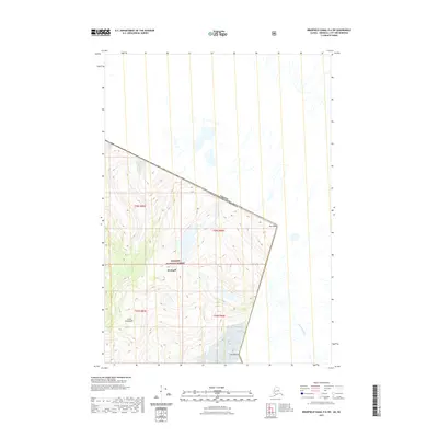
2021 Map of Bradfield Canal D-6 SW
USGS Topo · Published 2021About this map
The international boundary between Alaska and British Columbia cuts through the high-elevation terrain shown in this 2021 survey. Portions of the Tongass National Forest dominate the American side of the border, providing a clear look at the topographic relief of the Stikine region. The map captures the dividing line between the Wrangell borough and Canadian territory, marked by prominent peaks such as Mt Talbot in the north and Mt Gallatin to the south. This area is defined by its dramatic drainage patterns, where the Tasakilt River flows through the glacial landscape on the Canadian side. The survey offers a modern record of the remote borderlands where the Coast Mountains meet the interior, serving as a critical reference for understanding the precise path of the boundary through this wilderness.
Find a feature on this map
5 named features on this map. Tap any name to fly to it.
Don’t see what you’re looking for? This feature index may not catch every label — zoom into the map to look around manually.
Map Details
Editions of this 2021 Bradfield Canal D-6 SW Map
This is the sole edition of this map. No revisions or reprints were ever made.
Other maps of this area

1948 · Petersburg C-1
USGS Topo · 1:63,360

1951 · Bradfield Canal
USGS Topo · 1:250,000

1952 · Petersburg
USGS Topo · 1:250,000

1953 · Petersburg C-1
USGS Topo · 1:63,360

1954 · Bradfield Canal
USGS Topo · 1:250,000

1955 · Bradfield canal D-6
USGS Topo · 1:63,360

1955 · Bradfield canal C-6
USGS Topo · 1:63,360

1955 · Bradfield Canal
USGS Topo · 1:250,000

1960 · Petersburg
USGS Topo · 1:250,000

1961 · Petersburg D-1
USGS Topo · 1:63,360